Cuevas Bajas geodata
Cuevas Bajas (Andalusia) is a seat of a third-order administrative division; located in Spain in Europe/Madrid (GMT+2) time zone. With population of 1,476 people, there are 2481 cities with bigger population in this country. Compared to other cities in Spain, 93.6% of cities are located further ↑North; 66% of cities are located further →East and 73.1% of cities have higher elevation than Cuevas Bajas. Note1


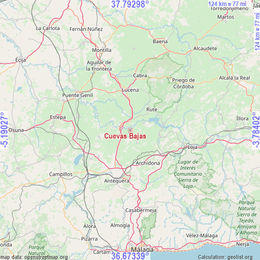
Cuevas Bajas GPS coordinates[2]
37° 14' 6.936" North, 4° 29' 13.704" West
| Map corner | latitude | longitude |
|---|---|---|
| Upper-left | 37.79298°, | -5.19027° |
| Center: | 37.23526°, | -4.48714° |
| Lower-right: | 36.67339°, | -3.78402° |
| Map W x H: | 124.5×124.5 km | = 77.4×77.4mi |
| max Lat: | 43.74134° ⇑93.6% North |
| Cuevas Bajas: | 37.23526° |
| min Lat: | ⇓6.4% South 27.64134° |
| min Long | Cuevas Bajas | max Long |
| -18.00367° | -4.48714° | 4.2899° |
| W 34%⇐ | ⇒66% E |
Elevation
Elevation of Cuevas Bajas is 329 m = 1079 ft, and this is 269 m = 883 ft below average elevation for this country.
| Max E: |
1682 m = 5518 ft | 73.1% |
| Avg. | 598 m = 1962 ft | |
| Cuevas Bajas | 329 m = 1079 ft | |
Min E: |
0 m = 0 ft | 26.9% |
See also: Spain elevation on elevation.city.
Geographical zone
Cuevas Bajas is located in North temperate zone (between Tropic of Cancer and the Arctic Circle). Distance of this Northern Tropic circle is 1534.3 km =953.4 mi to South.| Distance of | km | miles | from Cuevas Bajas |
|---|---|---|---|
| North Pole | 5866.9 | 3645.5 | to North |
| Arctic Circle | 3261 | 2026.3 | to North |
| Tropic Cancer | 1534.3 | 953.4 | to South |
| Equator | 4140.2 | 2572.6 | to South |


Nearby cities:
15 places around Cuevas Bajas: (largest is in red/bold)
• Alameda
15.5 km =9.6 mi,  258°
258°
• Archidona
17.7 km =11 mi,  150°
150°
• Badolatosa
18.3 km =11.4 mi,  296°
296°
• Benamejí
6 km =3.7 mi,  307°
307°
• Cuevas de San Marcos
7.3 km =4.5 mi,  61°
61°
• Encinas Reales
4.3 km =2.7 mi,  358°
358°
• Fuente de Piedra
24.2 km =15 mi,  242°
242°
• Humilladero
23.4 km =14.5 mi,  234°
234°
• Iznájar
16 km =9.9 mi,  81°
81°
• Lucena
19.3 km =12 mi,  0°
0°
• Mollina
19.4 km =12.1 mi, 230°
• Palenciana
8.6 km =5.3 mi,  279°
279°
• Rute
14.6 km =9.1 mi,  45°
45°
• Villanueva de Algaidas
6.6 km =4.1 mi, 150°
• Villanueva de Tapia
14.8 km =9.2 mi,  113°
113°
Sources, notices
• [Note1] Compared only with cities in Spain existing in our database
• [Src1] Map data: © OpenStreetMap contributors (CC-BY-SA)
• [Src2] Other city data from geonames.org with taken over terms of usage.
• [Src3] Geographical zone / Annual Mean Temperature by Robert A. Rohde @ Wikipedia
