Mojacar geodata
Mojacar (Andalusia) is a seat of a third-order administrative division; located in Spain in Europe/Madrid (GMT+2) time zone. With population of 5,154 people, there are 1273 cities with bigger population in this country. Compared to other cities in Spain, 94.6% of cities are located further ↑North; 69% of cities are located further ←West and 83.5% of cities have higher elevation than Mojacar. Note1


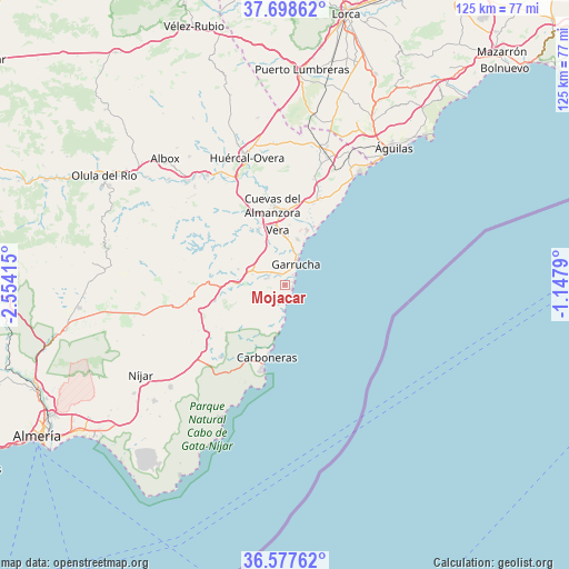
Mojacar GPS coordinates[2]
37° 8' 24.72" North, 1° 51' 3.672" West
| Map corner | latitude | longitude |
|---|---|---|
| Upper-left | 37.69862°, | -2.55415° |
| Center: | 37.1402°, | -1.85102° |
| Lower-right: | 36.57762°, | -1.1479° |
| Map W x H: | 124.6×124.6 km | = 77.4×77.4mi |
| max Lat: | 43.74134° ⇑94.6% North |
| Mojacar: | 37.1402° |
| min Lat: | ⇓5.4% South 27.64134° |
| min Long | Mojacar | max Long |
| -18.00367° | -1.85102° | 4.2899° |
| W 69%⇐ | ⇒31% E |
Elevation
Elevation of Mojacar is 162 m = 531 ft, and this is 436 m = 1430 ft below average elevation for this country.
| Max E: |
1682 m = 5518 ft | 83.5% |
| Avg. | 598 m = 1962 ft | |
| Mojacar | 162 m = 531 ft | |
Min E: |
0 m = 0 ft | 16.5% |
See also: Spain elevation on elevation.city.
Geographical zone
Mojacar is located in North temperate zone (between Tropic of Cancer and the Arctic Circle). Distance of this Northern Tropic circle is 1523.7 km =946.8 mi to South.| Distance of | km | miles | from Mojacar |
|---|---|---|---|
| North Pole | 5877.5 | 3652.1 | to North |
| Arctic Circle | 3271.6 | 2032.9 | to North |
| Tropic Cancer | 1523.7 | 946.8 | to South |
| Equator | 4129.6 | 2566 | to South |


Nearby cities:
15 places around Mojacar: (largest is in red/bold)
• Antas
13.1 km =8.1 mi,  333°
333°
• Arboleas
30.6 km =19 mi,  319°
319°
• Bédar
13 km =8.1 mi,  297°
297°
• Carboneras
16.5 km =10.3 mi,  194°
194°
• Cuevas del Almanzora
17.6 km =10.9 mi,  350°
350°
• Garrucha
5.2 km =3.2 mi,  28°
28°
• Guazamara
24.1 km =15 mi,  14°
14°
• Huércal-Overa
28.9 km =18 mi,  343°
343°
• Lubrín
20.9 km =13 mi,  293°
293°
• Pulpí
31.6 km =19.6 mi,  17°
17°
• Sorbas
24.6 km =15.3 mi,  258°
258°
• Turre
4.1 km =2.5 mi, 288°
• Uleila del Campo
31.7 km =19.7 mi,  278°
278°
• Vera
11.5 km =7.1 mi,  356°
356°
• Zurgena
28 km =17.4 mi, 323°
Sources, notices
• [Note1] Compared only with cities in Spain existing in our database
• [Src1] Map data: © OpenStreetMap contributors (CC-BY-SA)
• [Src2] Other city data from geonames.org with taken over terms of usage.
• [Src3] Geographical zone / Annual Mean Temperature by Robert A. Rohde @ Wikipedia
