Garrucha geodata
Garrucha (Andalusia) is a seat of a third-order administrative division; located in Spain in Europe/Madrid (GMT+2) time zone. With population of 6,920 people, there are 1044 cities with bigger population in this country. Compared to other cities in Spain, 94.2% of cities are located further ↑North; 69.3% of cities are located further ←West and 96.8% of cities have higher elevation than Garrucha. Note1


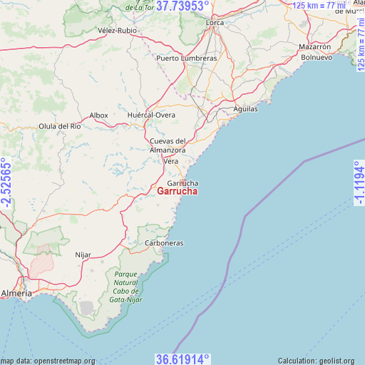
Garrucha GPS coordinates[2]
37° 10' 53.076" North, 1° 49' 21.072" West
| Map corner | latitude | longitude |
|---|---|---|
| Upper-left | 37.73953°, | -2.52565° |
| Center: | 37.18141°, | -1.82252° |
| Lower-right: | 36.61914°, | -1.1194° |
| Map W x H: | 124.6×124.6 km | = 77.4×77.4mi |
| max Lat: | 43.74134° ⇑94.2% North |
| Garrucha: | 37.18141° |
| min Lat: | ⇓5.8% South 27.64134° |
| min Long | Garrucha | max Long |
| -18.00367° | -1.82252° | 4.2899° |
| W 69.3%⇐ | ⇒30.7% E |
Elevation
Elevation of Garrucha is 16 m = 52 ft, and this is 582 m = 1909 ft below average elevation for this country.
| Max E: |
1682 m = 5518 ft | 96.8% |
| Avg. | 598 m = 1962 ft | |
| Garrucha | 16 m = 52 ft | |
Min E: |
0 m = 0 ft | 3.2% |
See also: Spain elevation on elevation.city.
Geographical zone
Garrucha is located in North temperate zone (between Tropic of Cancer and the Arctic Circle). Distance of this Northern Tropic circle is 1528.3 km =949.6 mi to South.| Distance of | km | miles | from Garrucha |
|---|---|---|---|
| North Pole | 5872.9 | 3649.2 | to North |
| Arctic Circle | 3267 | 2030 | to North |
| Tropic Cancer | 1528.3 | 949.6 | to South |
| Equator | 4134.2 | 2568.9 | to South |


Nearby cities:
15 places around Garrucha: (largest is in red/bold)
• Antas
11 km =6.8 mi,  310°
310°
• Arboleas
29.1 km =18.1 mi, 310°
• Bédar
14.2 km =8.8 mi,  275°
275°
• Carboneras
21.6 km =13.4 mi,  197°
197°
• Cuevas del Almanzora
13.9 km =8.6 mi,  337°
337°
• Guazamara
19.1 km =11.9 mi,  10°
10°
• Huércal-Overa
25.4 km =15.8 mi, 335°
• Lubrín
22 km =13.7 mi, 279°
• Mojacar
5.2 km =3.2 mi,  208°
208°
• Pulpí
26.5 km =16.5 mi,  15°
15°
• Sorbas
28.3 km =17.6 mi,  250°
250°
• Turre
7.2 km =4.5 mi,  243°
243°
• Vera
7.6 km =4.7 mi,  334°
334°
• Zurgena
26.3 km =16.3 mi, 312°
• Águilas
32.8 km =20.4 mi,  40°
40°
Sources, notices
• [Note1] Compared only with cities in Spain existing in our database
• [Src1] Map data: © OpenStreetMap contributors (CC-BY-SA)
• [Src2] Other city data from geonames.org with taken over terms of usage.
• [Src3] Geographical zone / Annual Mean Temperature by Robert A. Rohde @ Wikipedia
