Antas geodata
Antas (Andalusia) is a populated place; located in Spain in Europe/Madrid (GMT+2) time zone. With population of 3,166 people, there are 1672 cities with bigger population in this country. Compared to other cities in Spain, 93.5% of cities are located further ↑North; 68.3% of cities are located further ←West and 87.2% of cities have higher elevation than Antas. Note1


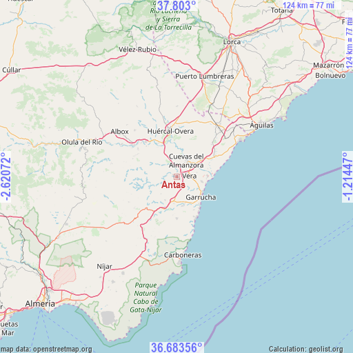
Antas GPS coordinates[2]
37° 14' 43.296" North, 1° 55' 3.36" West
| Map corner | latitude | longitude |
|---|---|---|
| Upper-left | 37.803°, | -2.62072° |
| Center: | 37.24536°, | -1.9176° |
| Lower-right: | 36.68356°, | -1.21447° |
| Map W x H: | 124.5×124.5 km | = 77.4×77.4mi |
| max Lat: | 43.74134° ⇑93.5% North |
| Antas: | 37.24536° |
| min Lat: | ⇓6.5% South 27.64134° |
| min Long | Antas | max Long |
| -18.00367° | -1.9176° | 4.2899° |
| W 68.3%⇐ | ⇒31.7% E |
Elevation
Elevation of Antas is 108 m = 354 ft, and this is 490 m = 1608 ft below average elevation for this country.
| Max E: |
1682 m = 5518 ft | 87.2% |
| Avg. | 598 m = 1962 ft | |
| Antas | 108 m = 354 ft | |
Min E: |
0 m = 0 ft | 12.8% |
See also: Spain elevation on elevation.city.
Geographical zone
Antas is located in North temperate zone (between Tropic of Cancer and the Arctic Circle). Distance of this Northern Tropic circle is 1535.4 km =954.1 mi to South.| Distance of | km | miles | from Antas |
|---|---|---|---|
| North Pole | 5865.8 | 3644.8 | to North |
| Arctic Circle | 3259.9 | 2025.6 | to North |
| Tropic Cancer | 1535.4 | 954.1 | to South |
| Equator | 4141.3 | 2573.3 | to South |


Nearby cities:
15 places around Antas: (largest is in red/bold)
• Albánchez
23.8 km =14.8 mi,  280°
280°
• Arboleas
18.1 km =11.2 mi,  310°
310°
• Bédar
8.1 km =5 mi,  224°
224°
• Cuevas del Almanzora
6.5 km =4 mi,  28°
28°
• Cóbdar
26 km =16.2 mi,  273°
273°
• Garrucha
11 km =6.8 mi,  130°
130°
• Guazamara
16.6 km =10.3 mi,  45°
45°
• Huércal-Overa
16.1 km =10 mi,  352°
352°
• Lubrín
13.6 km =8.5 mi,  255°
255°
• Mojacar
13.1 km =8.1 mi,  153°
153°
• Pulpí
24 km =14.9 mi,  39°
39°
• Sorbas
24.5 km =15.2 mi,  227°
227°
• Turre
10.5 km =6.5 mi,  169°
169°
• Vera
5.2 km =3.2 mi,  92°
92°
• Zurgena
15.3 km =9.5 mi, 314°
Sources, notices
• [Note1] Compared only with cities in Spain existing in our database
• [Src1] Map data: © OpenStreetMap contributors (CC-BY-SA)
• [Src2] Other city data from geonames.org with taken over terms of usage.
• [Src3] Geographical zone / Annual Mean Temperature by Robert A. Rohde @ Wikipedia
