Muro geodata
Muro (Balearic Islands) is a seat of a third-order administrative division; located in Spain in Europe/Madrid (GMT+2) time zone. With population of 6,610 people, there are 1078 cities with bigger population in this country. Compared to other cities in Spain, 73.7% of cities are located further ↑North; 99.1% of cities are located further ←West and 89.6% of cities have higher elevation than Muro. Note1


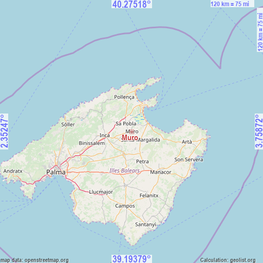
Muro GPS coordinates[2]
39° 44' 11.796" North, 3° 3' 20.124" East
| Map corner | latitude | longitude |
|---|---|---|
| Upper-left | 40.27518°, | 2.35247° |
| Center: | 39.73661°, | 3.05559° |
| Lower-right: | 39.19379°, | 3.75872° |
| Map W x H: | 120.2×120.2 km | = 74.7×74.7mi |
| max Lat: | 43.74134° ⇑73.7% North |
| Muro: | 39.73661° |
| min Lat: | ⇓26.3% South 27.64134° |
| min Long | Muro | max Long |
| -18.00367° | 3.05559° | 4.2899° |
| W 99.1%⇐ | ⇒0.90000000000001% E |
Elevation
Elevation of Muro is 72 m = 236 ft, and this is 526 m = 1726 ft below average elevation for this country.
| Max E: |
1682 m = 5518 ft | 89.6% |
| Avg. | 598 m = 1962 ft | |
| Muro | 72 m = 236 ft | |
Min E: |
0 m = 0 ft | 10.4% |
See also: Spain elevation on elevation.city.
Geographical zone
Muro is located in North temperate zone (between Tropic of Cancer and the Arctic Circle). Distance of this Northern Tropic circle is 1812.4 km =1126.2 mi to South.| Distance of | km | miles | from Muro |
|---|---|---|---|
| North Pole | 5588.8 | 3472.7 | to North |
| Arctic Circle | 2982.9 | 1853.5 | to North |
| Tropic Cancer | 1812.4 | 1126.2 | to South |
| Equator | 4418.3 | 2745.4 | to South |


Nearby cities:
15 places around Muro: (largest is in red/bold)
• Alcúdia
14.1 km =8.8 mi,  23°
23°
• Ariany
10.7 km =6.6 mi,  153°
153°
• Búger
6.6 km =4.1 mi,  291°
291°
• Campanet
8.8 km =5.5 mi,  298°
298°
• Can Picafort
9.1 km =5.7 mi,  69°
69°
• Costitx
12.7 km =7.9 mi,  225°
225°
• Inca
12.5 km =7.8 mi,  262°
262°
• Llubí
5.9 km =3.7 mi, 225°
• Maria de la Salut
8.3 km =5.2 mi,  169°
169°
• Petra
14.5 km =9 mi,  160°
160°
• Port d'Alcúdia
13.4 km =8.3 mi,  29°
29°
• Santa Margalida
5.6 km =3.5 mi,  134°
134°
• Selva
13.4 km =8.3 mi,  278°
278°
• Sineu
11.2 km =7 mi,  200°
200°
• sa Pobla
4.5 km =2.8 mi,  323°
323°
Sources, notices
• [Note1] Compared only with cities in Spain existing in our database
• [Src1] Map data: © OpenStreetMap contributors (CC-BY-SA)
• [Src2] Other city data from geonames.org with taken over terms of usage.
• [Src3] Geographical zone / Annual Mean Temperature by Robert A. Rohde @ Wikipedia
