Santafé geodata
Santafé (Andalusia) is a populated place; located in Spain in Europe/Madrid (GMT+2) time zone. With population of 15,430 people, there are 606 cities with bigger population in this country. Compared to other cities in Spain, 94.1% of cities are located further ↑North; 55.7% of cities are located further →East and 56% of cities have higher elevation than Santafé. Note1


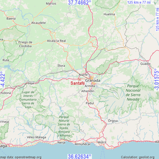
Santafé GPS coordinates[2]
37° 11' 18.816" North, 3° 43' 7.932" West
| Map corner | latitude | longitude |
|---|---|---|
| Upper-left | 37.74662°, | -4.422° |
| Center: | 37.18856°, | -3.71887° |
| Lower-right: | 36.62634°, | -3.01575° |
| Map W x H: | 124.6×124.6 km | = 77.4×77.4mi |
| max Lat: | 43.74134° ⇑94.1% North |
| Santafé: | 37.18856° |
| min Lat: | ⇓5.9% South 27.64134° |
| min Long | Santafé | max Long |
| -18.00367° | -3.71887° | 4.2899° |
| W 44.3%⇐ | ⇒55.7% E |
Elevation
Elevation of Santafé is 582 m = 1909 ft, and this is 16 m = 52 ft below average elevation for this country.
| Max E: |
1682 m = 5518 ft | 56% |
| Avg. | 598 m = 1962 ft | |
| Santafé | 582 m = 1909 ft | |
Min E: |
0 m = 0 ft | 44% |
See also: Spain elevation on elevation.city.
Geographical zone
Santafé is located in North temperate zone (between Tropic of Cancer and the Arctic Circle). Distance of this Northern Tropic circle is 1529.1 km =950.1 mi to South.| Distance of | km | miles | from Santafé |
|---|---|---|---|
| North Pole | 5872.1 | 3648.8 | to North |
| Arctic Circle | 3266.2 | 2029.5 | to North |
| Tropic Cancer | 1529.1 | 950.1 | to South |
| Equator | 4135 | 2569.4 | to South |


Nearby cities:
15 places around Santafé: (largest is in red/bold)
• Albolote
7.4 km =4.6 mi,  50°
50°
• Armilla
9.7 km =6 mi,  120°
120°
• Atarfe
4.9 km =3 mi,  35°
35°
• Chauchina
4.8 km =3 mi,  284°
284°
• Churriana de la Vega
8.1 km =5 mi,  126°
126°
• Cijuela
8.3 km =5.2 mi, 277°
• Cúllar-Vega
5.8 km =3.6 mi, 132°
• Fuente Vaqueros
6.7 km =4.2 mi,  301°
301°
• Granada
9.9 km =6.2 mi,  90°
90°
• Las Gabias
7.3 km =4.5 mi,  143°
143°
• Láchar
10.1 km =6.3 mi,  274°
274°
• Maracena
7.7 km =4.8 mi,  74°
74°
• Peligros
9.3 km =5.8 mi,  58°
58°
• Pinos Puente
7.5 km =4.7 mi,  338°
338°
• Valderrubio
10.3 km =6.4 mi, 299°
Sources, notices
• [Note1] Compared only with cities in Spain existing in our database
• [Src1] Map data: © OpenStreetMap contributors (CC-BY-SA)
• [Src2] Other city data from geonames.org with taken over terms of usage.
• [Src3] Geographical zone / Annual Mean Temperature by Robert A. Rohde @ Wikipedia
