Malpartida de Plasencia geodata
Malpartida de Plasencia (Extremadura) is a seat of a third-order administrative division; located in Spain in Europe/Madrid (GMT+2) time zone. With population of 4,275 people, there are 1423 cities with bigger population in this country. Compared to other cities in Spain, 70.6% of cities are located further ↑North; 86.6% of cities are located further →East and 65.2% of cities have higher elevation than Malpartida de Plasencia. Note1
Administrative division(s):
- Level 1: Extremadura
- Level 2: Provincia de Cáceres
- Level 3: Malpartida de Plasencia
Current local time in Malpartida de Plasencia:
10:49 PM, ThursdayDifference from your time zone: hours


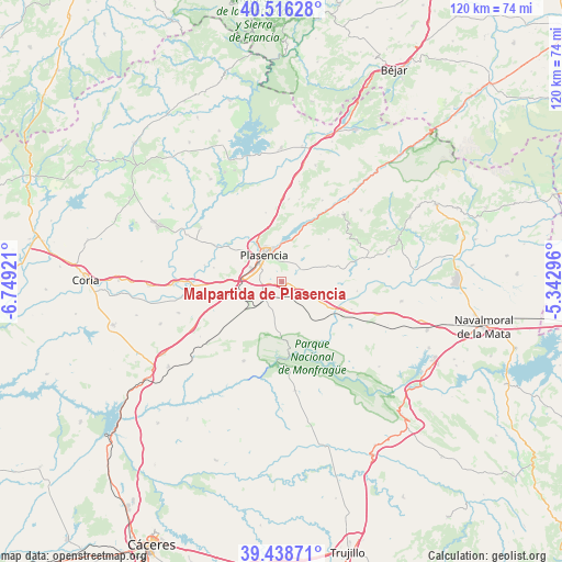
Malpartida de Plasencia GPS coordinates[2]
39° 58' 46.632" North, 6° 2' 45.924" West
| Map corner | latitude | longitude |
|---|---|---|
| Upper-left | 40.51628°, | -6.74921° |
| Center: | 39.97962°, | -6.04609° |
| Lower-right: | 39.43871°, | -5.34296° |
| Map W x H: | 119.8×119.8 km | = 74.4×74.4mi |
| max Lat: | 43.74134° ⇑70.6% North |
| Malpartida de Plasencia: | 39.97962° |
| min Lat: | ⇓29.4% South 27.64134° |
| min Long | Malpartida de P | max Long |
| -18.00367° | -6.04609° | 4.2899° |
| W 13.4%⇐ | ⇒86.6% E |
Elevation
Elevation of Malpartida de Plasencia is 457 m = 1499 ft, and this is 141 m = 463 ft below average elevation for this country.
| Max E: |
1682 m = 5518 ft | 65.2% |
| Avg. | 598 m = 1962 ft | |
| Malpartida de Plasencia | 457 m = 1499 ft | |
Min E: |
0 m = 0 ft | 34.8% |
See also: Spain elevation on elevation.city.
Geographical zone
Malpartida de Plasencia is located in North temperate zone (between Tropic of Cancer and the Arctic Circle). Distance of this Northern Tropic circle is 1839.4 km =1142.9 mi to South.| Distance of | km | miles | from Malpartida de Plasencia |
|---|---|---|---|
| North Pole | 5561.7 | 3455.9 | to North |
| Arctic Circle | 2955.9 | 1836.7 | to North |
| Tropic Cancer | 1839.4 | 1142.9 | to South |
| Equator | 4445.3 | 2762.2 | to South |


Nearby cities:
15 places around Malpartida de Plasencia: (largest is in red/bold)
• Arroyomolinos de la Vera
18.5 km =11.5 mi,  63°
63°
• Barrado
18.3 km =11.4 mi,  50°
50°
• Cabezabellosa
18 km =11.2 mi,  12°
12°
• Cabrero
19.8 km =12.3 mi,  41°
41°
• Carcaboso
16.3 km =10.1 mi,  298°
298°
• Casas del Castañar
18.6 km =11.6 mi, 40°
• El Torno
19.4 km =12.1 mi,  26°
26°
• Galisteo
18.9 km =11.7 mi,  268°
268°
• Gargüera
13.6 km =8.5 mi, 47°
• Mirabel
20.6 km =12.8 mi,  230°
230°
• Oliva de Plasencia
15.1 km =9.4 mi,  346°
346°
• Plasencia
6.8 km =4.2 mi,  327°
327°
• Serradilla
18.6 km =11.6 mi,  205°
205°
• Tejeda de Tiétar
15.6 km =9.7 mi,  74°
74°
• Villar de Plasencia
17.6 km =10.9 mi, 5°
Sources, notices
• [Note1] Compared only with cities in Spain existing in our database
• [Src1] Map data: © OpenStreetMap contributors (CC-BY-SA)
• [Src2] Other city data from geonames.org with taken over terms of usage.
• [Src3] Geographical zone / Annual Mean Temperature by Robert A. Rohde @ Wikipedia
