Carcaboso geodata
Carcaboso (Extremadura) is a seat of a third-order administrative division; located in Spain in Europe/Madrid (GMT+2) time zone. With population of 1,019 people, there are 2914 cities with bigger population in this country. Compared to other cities in Spain, 69.6% of cities are located further ↑North; 88.6% of cities are located further →East and 76.6% of cities have higher elevation than Carcaboso. Note1


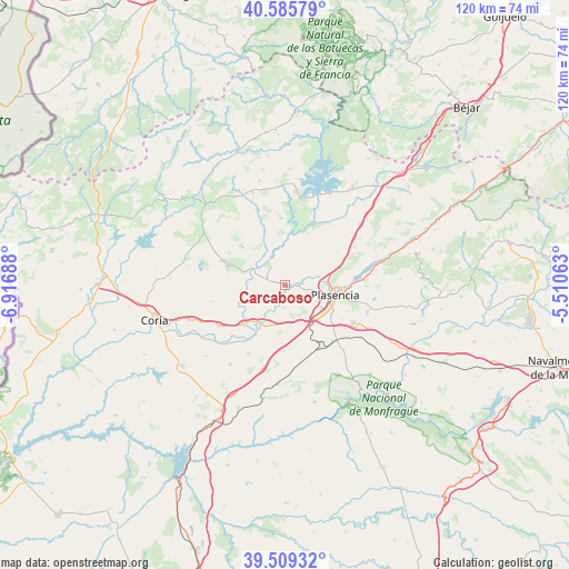
Carcaboso GPS coordinates[2]
40° 2' 58.848" North, 6° 12' 49.5" West
| Map corner | latitude | longitude |
|---|---|---|
| Upper-left | 40.58579°, | -6.91688° |
| Center: | 40.04968°, | -6.21375° |
| Lower-right: | 39.50932°, | -5.51063° |
| Map W x H: | 119.7×119.7 km | = 74.4×74.4mi |
| max Lat: | 43.74134° ⇑69.6% North |
| Carcaboso: | 40.04968° |
| min Lat: | ⇓30.4% South 27.64134° |
| min Long | Carcaboso | max Long |
| -18.00367° | -6.21375° | 4.2899° |
| W 11.4%⇐ | ⇒88.6% E |
Elevation
Elevation of Carcaboso is 277 m = 909 ft, and this is 321 m = 1053 ft below average elevation for this country.
| Max E: |
1682 m = 5518 ft | 76.6% |
| Avg. | 598 m = 1962 ft | |
| Carcaboso | 277 m = 909 ft | |
Min E: |
0 m = 0 ft | 23.4% |
See also: Spain elevation on elevation.city.
Geographical zone
Carcaboso is located in North temperate zone (between Tropic of Cancer and the Arctic Circle). Distance of this Northern Tropic circle is 1847.2 km =1147.8 mi to South.| Distance of | km | miles | from Carcaboso |
|---|---|---|---|
| North Pole | 5554 | 3451.1 | to North |
| Arctic Circle | 2948.1 | 1831.9 | to North |
| Tropic Cancer | 1847.2 | 1147.8 | to South |
| Equator | 4453.1 | 2767 | to South |


Nearby cities:
15 places around Carcaboso: (largest is in red/bold)
• Aceituna
15.1 km =9.4 mi,  317°
317°
• Ahigal
15.7 km =9.8 mi,  7°
7°
• Galisteo
9.4 km =5.8 mi,  209°
209°
• Guijo de Galisteo
17.4 km =10.8 mi,  286°
286°
• Guijo de Granadilla
16.6 km =10.3 mi, 14°
• Malpartida de Plasencia
16.3 km =10.1 mi,  118°
118°
• Montehermoso
12.3 km =7.6 mi, 290°
• Morcillo
16 km =9.9 mi,  257°
257°
• Oliva de Plasencia
12.9 km =8 mi,  57°
57°
• Plasencia
10.9 km =6.8 mi,  100°
100°
• Ríolobos
16.3 km =10.1 mi, 208°
• Santa Cruz de Paniagua
19.1 km =11.9 mi,  325°
325°
• Santibáñez el Bajo
14.1 km =8.8 mi,  356°
356°
• Valdeobispo
4.7 km =2.9 mi, 322°
• Villar de Plasencia
18.6 km =11.6 mi, 58°
Sources, notices
• [Note1] Compared only with cities in Spain existing in our database
• [Src1] Map data: © OpenStreetMap contributors (CC-BY-SA)
• [Src2] Other city data from geonames.org with taken over terms of usage.
• [Src3] Geographical zone / Annual Mean Temperature by Robert A. Rohde @ Wikipedia
