Plasencia geodata
Plasencia (Extremadura) is a seat of a third-order administrative division; located in Spain in Europe/Madrid (GMT+2) time zone. With population of 41,148 people, there are 213 cities with bigger population in this country. Compared to other cities in Spain, 69.9% of cities are located further ↑North; 87.3% of cities are located further →East and 71% of cities have higher elevation than Plasencia. Note1


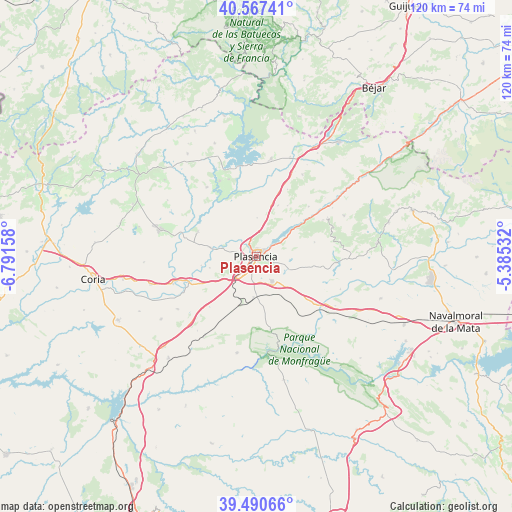
Plasencia GPS coordinates[2]
40° 1' 52.176" North, 6° 5' 18.42" West
| Map corner | latitude | longitude |
|---|---|---|
| Upper-left | 40.56741°, | -6.79158° |
| Center: | 40.03116°, | -6.08845° |
| Lower-right: | 39.49066°, | -5.38532° |
| Map W x H: | 119.7×119.7 km | = 74.4×74.4mi |
| max Lat: | 43.74134° ⇑69.9% North |
| Plasencia: | 40.03116° |
| min Lat: | ⇓30.1% South 27.64134° |
| min Long | Plasencia | max Long |
| -18.00367° | -6.08845° | 4.2899° |
| W 12.7%⇐ | ⇒87.3% E |
Elevation
Elevation of Plasencia is 368 m = 1207 ft, and this is 230 m = 755 ft below average elevation for this country.
| Max E: |
1682 m = 5518 ft | 71% |
| Avg. | 598 m = 1962 ft | |
| Plasencia | 368 m = 1207 ft | |
Min E: |
0 m = 0 ft | 29% |
See also: Plasencia elevation on elevation.city.
Geographical zone
Plasencia is located in North temperate zone (between Tropic of Cancer and the Arctic Circle). Distance of this Northern Tropic circle is 1845.1 km =1146.5 mi to South.| Distance of | km | miles | from Plasencia |
|---|---|---|---|
| North Pole | 5556 | 3452.3 | to North |
| Arctic Circle | 2950.1 | 1833.1 | to North |
| Tropic Cancer | 1845.1 | 1146.5 | to South |
| Equator | 4451 | 2765.7 | to South |


Nearby cities:
15 places around Plasencia: (largest is in red/bold)
• Barrado
18.7 km =11.6 mi,  71°
71°
• Cabezabellosa
14 km =8.7 mi,  32°
32°
• Cabrero
19 km =11.8 mi,  61°
61°
• Carcaboso
10.9 km =6.8 mi,  280°
280°
• Casas del Castañar
17.8 km =11.1 mi, 61°
• El Torno
16.9 km =10.5 mi,  46°
46°
• Galisteo
16.4 km =10.2 mi,  248°
248°
• Gargüera
14.1 km =8.8 mi,  76°
76°
• Guijo de Granadilla
19.1 km =11.9 mi,  340°
340°
• Jarilla
17.2 km =10.7 mi, 25°
• Malpartida de Plasencia
6.8 km =4.2 mi,  147°
147°
• Oliva de Plasencia
9 km =5.6 mi,  1°
1°
• Tejeda de Tiétar
18.7 km =11.6 mi,  94°
94°
• Valdeobispo
14.7 km =9.1 mi,  293°
293°
• Villar de Plasencia
12.9 km =8 mi,  23°
23°
Sources, notices
• [Note1] Compared only with cities in Spain existing in our database
• [Src1] Map data: © OpenStreetMap contributors (CC-BY-SA)
• [Src2] Other city data from geonames.org with taken over terms of usage.
• [Src3] Geographical zone / Annual Mean Temperature by Robert A. Rohde @ Wikipedia
