Galisteo geodata
Galisteo (Extremadura) is a seat of a third-order administrative division; located in Spain in Europe/Madrid (GMT+2) time zone. With population of 2,030 people, there are 2146 cities with bigger population in this country. Compared to other cities in Spain, 70.6% of cities are located further ↑North; 89.1% of cities are located further →East and 74.5% of cities have higher elevation than Galisteo. Note1


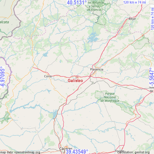
Galisteo GPS coordinates[2]
39° 58' 35.112" North, 6° 16' 4.152" West
| Map corner | latitude | longitude |
|---|---|---|
| Upper-left | 40.5131°, | -6.97095° |
| Center: | 39.97642°, | -6.26782° |
| Lower-right: | 39.43549°, | -5.5647° |
| Map W x H: | 119.8×119.8 km | = 74.4×74.4mi |
| max Lat: | 43.74134° ⇑70.6% North |
| Galisteo: | 39.97642° |
| min Lat: | ⇓29.4% South 27.64134° |
| min Long | Galisteo | max Long |
| -18.00367° | -6.26782° | 4.2899° |
| W 10.9%⇐ | ⇒89.1% E |
Elevation
Elevation of Galisteo is 305 m = 1001 ft, and this is 293 m = 961 ft below average elevation for this country.
| Max E: |
1682 m = 5518 ft | 74.5% |
| Avg. | 598 m = 1962 ft | |
| Galisteo | 305 m = 1001 ft | |
Min E: |
0 m = 0 ft | 25.5% |
See also: Spain elevation on elevation.city.
Geographical zone
Galisteo is located in North temperate zone (between Tropic of Cancer and the Arctic Circle). Distance of this Northern Tropic circle is 1839 km =1142.7 mi to South.| Distance of | km | miles | from Galisteo |
|---|---|---|---|
| North Pole | 5562.1 | 3456.1 | to North |
| Arctic Circle | 2956.2 | 1836.9 | to North |
| Tropic Cancer | 1839 | 1142.7 | to South |
| Equator | 4445 | 2762 | to South |


Nearby cities:
15 places around Galisteo: (largest is in red/bold)
• Aceituna
20.1 km =12.5 mi,  343°
343°
• Carcaboso
9.4 km =5.8 mi,  29°
29°
• Casas de Millán
18.4 km =11.4 mi,  196°
196°
• Guijo de Galisteo
17.8 km =11.1 mi,  317°
317°
• Holguera
11.1 km =6.9 mi,  219°
219°
• Malpartida de Plasencia
18.9 km =11.7 mi,  88°
88°
• Mirabel
13 km =8.1 mi,  166°
166°
• Montehermoso
14.2 km =8.8 mi,  330°
330°
• Morcillo
12 km =7.5 mi,  293°
293°
• Pedroso de Acim
20.9 km =13 mi, 216°
• Plasencia
16.4 km =10.2 mi,  68°
68°
• Ríolobos
6.9 km =4.3 mi,  206°
206°
• Serradilla
19.7 km =12.2 mi,  146°
146°
• Torrejoncillo
19.2 km =11.9 mi,  242°
242°
• Valdeobispo
12 km =7.5 mi,  8°
8°
Sources, notices
• [Note1] Compared only with cities in Spain existing in our database
• [Src1] Map data: © OpenStreetMap contributors (CC-BY-SA)
• [Src2] Other city data from geonames.org with taken over terms of usage.
• [Src3] Geographical zone / Annual Mean Temperature by Robert A. Rohde @ Wikipedia
