Carcabuey geodata
Carcabuey (Andalusia) is a seat of a third-order administrative division; located in Spain in Europe/Madrid (GMT+2) time zone. With population of 2,857 people, there are 1770 cities with bigger population in this country. Compared to other cities in Spain, 91.6% of cities are located further ↑North; 63.5% of cities are located further →East and 53.6% of cities have higher elevation than Carcabuey. Note1


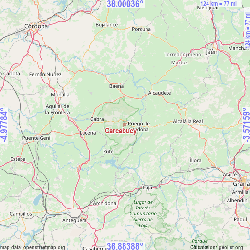
Carcabuey GPS coordinates[2]
37° 26' 39.12" North, 4° 16' 28.956" West
| Map corner | latitude | longitude |
|---|---|---|
| Upper-left | 38.00036°, | -4.97784° |
| Center: | 37.4442°, | -4.27471° |
| Lower-right: | 36.88388°, | -3.57159° |
| Map W x H: | 124.1×124.1 km | = 77.1×77.1mi |
| max Lat: | 43.74134° ⇑91.6% North |
| Carcabuey: | 37.4442° |
| min Lat: | ⇓8.4% South 27.64134° |
| min Long | Carcabuey | max Long |
| -18.00367° | -4.27471° | 4.2899° |
| W 36.5%⇐ | ⇒63.5% E |
Elevation
Elevation of Carcabuey is 617 m = 2024 ft, and this is 19 m = 62 ft above average elevation for this country.
| Max E: |
1682 m = 5518 ft | 53.6% |
| Carcabuey | 617 m 2024 ft | |
| Avg. | 598 m = 1962 ft | |
Min E: |
0 m = 0 ft | 46.4% |
See also: Spain elevation on elevation.city.
Geographical zone
Carcabuey is located in North temperate zone (between Tropic of Cancer and the Arctic Circle). Distance of this Northern Tropic circle is 1557.5 km =967.8 mi to South.| Distance of | km | miles | from Carcabuey |
|---|---|---|---|
| North Pole | 5843.7 | 3631.1 | to North |
| Arctic Circle | 3237.8 | 2011.9 | to North |
| Tropic Cancer | 1557.5 | 967.8 | to South |
| Equator | 4163.4 | 2587 | to South |


Nearby cities:
15 places around Carcabuey: (largest is in red/bold)
• Algarinejo
16.7 km =10.4 mi,  142°
142°
• Almedinilla
16.3 km =10.1 mi,  92°
92°
• Baena
19.6 km =12.2 mi,  347°
347°
• Cabra
15.1 km =9.4 mi,  282°
282°
• Cuevas de San Marcos
23.3 km =14.5 mi,  212°
212°
• Doña Mencía
14.1 km =8.8 mi,  329°
329°
• Fuente-Tójar
13.5 km =8.4 mi,  56°
56°
• Iznájar
21 km =13 mi,  188°
188°
• Lucena
19 km =11.8 mi,  258°
258°
• Luque
12.7 km =7.9 mi,  357°
357°
• Nueva-Carteya
23.2 km =14.4 mi,  312°
312°
• Priego de Córdoba
7 km =4.3 mi,  95°
95°
• Rute
15.4 km =9.6 mi, 212°
• Zagra
23 km =14.3 mi,  155°
155°
• Zuheros
11.6 km =7.2 mi,  341°
341°
Sources, notices
• [Note1] Compared only with cities in Spain existing in our database
• [Src1] Map data: © OpenStreetMap contributors (CC-BY-SA)
• [Src2] Other city data from geonames.org with taken over terms of usage.
• [Src3] Geographical zone / Annual Mean Temperature by Robert A. Rohde @ Wikipedia
