Rute geodata
Rute (Andalusia) is a seat of a third-order administrative division; located in Spain in Europe/Madrid (GMT+2) time zone. With population of 10,559 people, there are 824 cities with bigger population in this country. Compared to other cities in Spain, 92.7% of cities are located further ↑North; 64.6% of cities are located further →East and 50.1% of cities have lower elevation than Rute. Note1


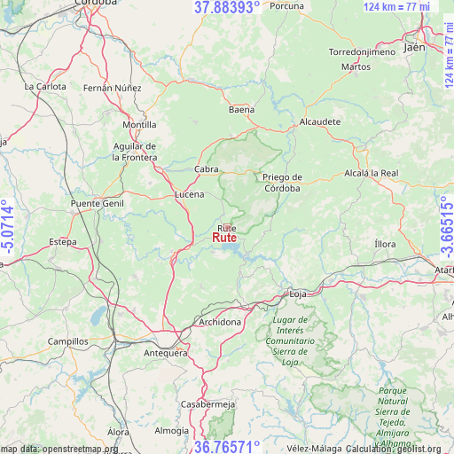
Rute GPS coordinates[2]
37° 19' 36.84" North, 4° 22' 5.772" West
| Map corner | latitude | longitude |
|---|---|---|
| Upper-left | 37.88393°, | -5.0714° |
| Center: | 37.3269°, | -4.36827° |
| Lower-right: | 36.76571°, | -3.66515° |
| Map W x H: | 124.3×124.3 km | = 77.2×77.2mi |
| max Lat: | 43.74134° ⇑92.7% North |
| Rute: | 37.3269° |
| min Lat: | ⇓7.3% South 27.64134° |
| min Long | Rute | max Long |
| -18.00367° | -4.36827° | 4.2899° |
| W 35.4%⇐ | ⇒64.6% E |
Elevation
Elevation of Rute is 658 m = 2159 ft, and this is 60 m = 197 ft above average elevation for this country.
| Max E: |
1682 m = 5518 ft | 49.9% |
| Rute | 658 m 2159 ft | |
| Avg. | 598 m = 1962 ft | |
Min E: |
0 m = 0 ft | 50.1% |
See also: Spain elevation on elevation.city.
Geographical zone
Rute is located in North temperate zone (between Tropic of Cancer and the Arctic Circle). Distance of this Northern Tropic circle is 1544.4 km =959.6 mi to South.| Distance of | km | miles | from Rute |
|---|---|---|---|
| North Pole | 5856.7 | 3639.2 | to North |
| Arctic Circle | 3250.8 | 2020 | to North |
| Tropic Cancer | 1544.4 | 959.6 | to South |
| Equator | 4150.4 | 2578.9 | to South |


Nearby cities:
15 places around Rute: (largest is in red/bold)
• Algarinejo
18.5 km =11.5 mi,  90°
90°
• Benamejí
16.6 km =10.3 mi,  246°
246°
• Cabra
17.5 km =10.9 mi,  338°
338°
• Carcabuey
15.4 km =9.6 mi,  32°
32°
• Cuevas Bajas
14.6 km =9.1 mi,  225°
225°
• Cuevas de San Marcos
7.8 km =4.8 mi,  211°
211°
• Encinas Reales
12.1 km =7.5 mi,  241°
241°
• Iznájar
9.3 km =5.8 mi,  145°
145°
• Lucena
13.8 km =8.6 mi,  311°
311°
• Moriles
24.4 km =15.2 mi,  299°
299°
• Palenciana
20.9 km =13 mi, 245°
• Priego de Córdoba
19.7 km =12.2 mi,  51°
51°
• Villanueva de Algaidas
17.5 km =10.9 mi,  204°
204°
• Villanueva de Tapia
16.3 km =10.1 mi,  169°
169°
• Zagra
19.3 km =12 mi,  114°
114°
Sources, notices
• [Note1] Compared only with cities in Spain existing in our database
• [Src1] Map data: © OpenStreetMap contributors (CC-BY-SA)
• [Src2] Other city data from geonames.org with taken over terms of usage.
• [Src3] Geographical zone / Annual Mean Temperature by Robert A. Rohde @ Wikipedia
