Zuheros geodata
Zuheros (Andalusia) is a seat of a third-order administrative division; located in Spain in Europe/Madrid (GMT+2) time zone. With population of 827 people, there are 3168 cities with bigger population in this country. Compared to other cities in Spain, 91.1% of cities are located further ↑North; 64% of cities are located further →East and 50.6% of cities have lower elevation than Zuheros. Note1


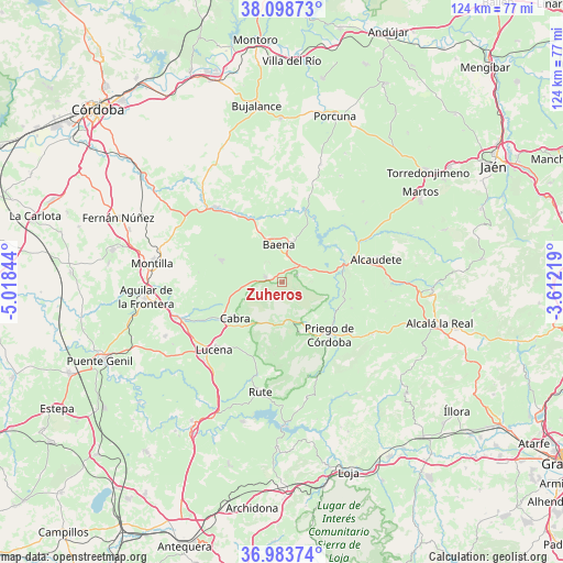
Zuheros GPS coordinates[2]
37° 32' 35.952" North, 4° 18' 55.116" West
| Map corner | latitude | longitude |
|---|---|---|
| Upper-left | 38.09873°, | -5.01844° |
| Center: | 37.54332°, | -4.31531° |
| Lower-right: | 36.98374°, | -3.61219° |
| Map W x H: | 124×124 km | = 77.1×77.1mi |
| max Lat: | 43.74134° ⇑91.1% North |
| Zuheros: | 37.54332° |
| min Lat: | ⇓8.9% South 27.64134° |
| min Long | Zuheros | max Long |
| -18.00367° | -4.31531° | 4.2899° |
| W 36%⇐ | ⇒64% E |
Elevation
Elevation of Zuheros is 665 m = 2182 ft, and this is 67 m = 220 ft above average elevation for this country.
| Max E: |
1682 m = 5518 ft | 49.4% |
| Zuheros | 665 m 2182 ft | |
| Avg. | 598 m = 1962 ft | |
Min E: |
0 m = 0 ft | 50.6% |
See also: Spain elevation on elevation.city.
Geographical zone
Zuheros is located in North temperate zone (between Tropic of Cancer and the Arctic Circle). Distance of this Northern Tropic circle is 1568.5 km =974.6 mi to South.| Distance of | km | miles | from Zuheros |
|---|---|---|---|
| North Pole | 5832.6 | 3624.2 | to North |
| Arctic Circle | 3226.7 | 2005 | to North |
| Tropic Cancer | 1568.5 | 974.6 | to South |
| Equator | 4174.4 | 2593.9 | to South |


Nearby cities:
15 places around Zuheros: (largest is in red/bold)
• Alcaudete
21.2 km =13.2 mi,  75°
75°
• Almedinilla
23 km =14.3 mi,  120°
120°
• Baena
8.2 km =5.1 mi,  355°
355°
• Cabra
13.7 km =8.5 mi,  234°
234°
• Carcabuey
11.6 km =7.2 mi,  161°
161°
• Castro del Río
22 km =13.7 mi,  318°
318°
• Doña Mencía
3.8 km =2.4 mi,  287°
287°
• Espejo
25.9 km =16.1 mi,  305°
305°
• Fuente-Tójar
15.3 km =9.5 mi,  103°
103°
• Lucena
21.2 km =13.2 mi, 225°
• Luque
3.5 km =2.2 mi,  62°
62°
• Monturque
24.8 km =15.4 mi,  251°
251°
• Nueva-Carteya
14.2 km =8.8 mi, 289°
• Priego de Córdoba
15.8 km =9.8 mi,  137°
137°
• Rute
24.5 km =15.2 mi,  190°
190°
Sources, notices
• [Note1] Compared only with cities in Spain existing in our database
• [Src1] Map data: © OpenStreetMap contributors (CC-BY-SA)
• [Src2] Other city data from geonames.org with taken over terms of usage.
• [Src3] Geographical zone / Annual Mean Temperature by Robert A. Rohde @ Wikipedia
