Velefique geodata
Velefique (Andalusia) is a seat of a third-order administrative division; located in Spain in Europe/Madrid (GMT+2) time zone. With population of 246 people, there are 4766 cities with bigger population in this country. Compared to other cities in Spain, 94% of cities are located further ↑North; 62.3% of cities are located further ←West and 81.9% of cities have lower elevation than Velefique. Note1


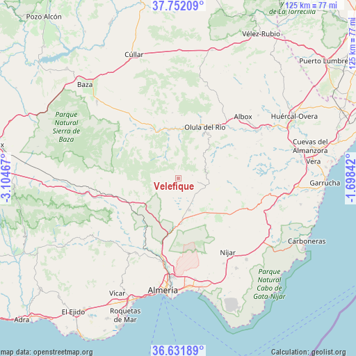
Velefique GPS coordinates[2]
37° 11' 38.652" North, 2° 24' 5.58" West
| Map corner | latitude | longitude |
|---|---|---|
| Upper-left | 37.75209°, | -3.10467° |
| Center: | 37.19407°, | -2.40155° |
| Lower-right: | 36.63189°, | -1.69842° |
| Map W x H: | 124.6×124.6 km | = 77.4×77.4mi |
| max Lat: | 43.74134° ⇑94% North |
| Velefique: | 37.19407° |
| min Lat: | ⇓6% South 27.64134° |
| min Long | Velefique | max Long |
| -18.00367° | -2.40155° | 4.2899° |
| W 62.3%⇐ | ⇒37.7% E |
Elevation
Elevation of Velefique is 916 m = 3005 ft, and this is 318 m = 1043 ft above average elevation for this country.
| Max E: |
1682 m = 5518 ft | 18.1% |
| Velefique | 916 m 3005 ft | |
| Avg. | 598 m = 1962 ft | |
Min E: |
0 m = 0 ft | 81.9% |
See also: Spain elevation on elevation.city.
Geographical zone
Velefique is located in North temperate zone (between Tropic of Cancer and the Arctic Circle). Distance of this Northern Tropic circle is 1529.7 km =950.5 mi to South.| Distance of | km | miles | from Velefique |
|---|---|---|---|
| North Pole | 5871.5 | 3648.4 | to North |
| Arctic Circle | 3265.6 | 2029.1 | to North |
| Tropic Cancer | 1529.7 | 950.5 | to South |
| Equator | 4135.6 | 2569.7 | to South |


Nearby cities:
15 places around Velefique: (largest is in red/bold)
• Alcudia de Monteagud
12.8 km =8 mi,  69°
69°
• Bayarque
15.5 km =9.6 mi,  348°
348°
• Benitagla
15 km =9.3 mi, 73°
• Benizalón
14.3 km =8.9 mi,  81°
81°
• Castro de Filabres
3.6 km =2.2 mi,  253°
253°
• Chercos
13.7 km =8.5 mi,  60°
60°
• Gérgal
14.9 km =9.3 mi,  235°
235°
• La Mojonera
11.4 km =7.1 mi,  343°
343°
• Laroya
13 km =8.1 mi,  27°
27°
• Olula de Castro
6.8 km =4.2 mi, 251°
• Sierro
14.3 km =8.9 mi,  1°
1°
• Suflí
16.1 km =10 mi, 4°
• Tabernas
16.1 km =10 mi,  176°
176°
• Tahal
11 km =6.8 mi, 69°
• Tíjola
17.1 km =10.6 mi, 350°
Sources, notices
• [Note1] Compared only with cities in Spain existing in our database
• [Src1] Map data: © OpenStreetMap contributors (CC-BY-SA)
• [Src2] Other city data from geonames.org with taken over terms of usage.
• [Src3] Geographical zone / Annual Mean Temperature by Robert A. Rohde @ Wikipedia
