Orihuela geodata
Orihuela (Valencia) is a seat of a third-order administrative division; located in Spain in Europe/Madrid (GMT+2) time zone. With population of 86,164 people, there are 102 cities with bigger population in this country. Compared to other cities in Spain, 87.9% of cities are located further ↑North; 77.6% of cities are located further ←West and 93.9% of cities have higher elevation than Orihuela. Note1


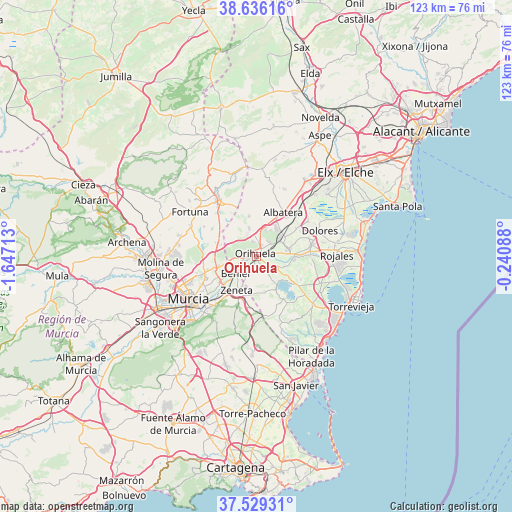
Orihuela GPS coordinates[2]
38° 5' 5.388" North, 0° 56' 38.436" West
| Map corner | latitude | longitude |
|---|---|---|
| Upper-left | 38.63616°, | -1.64713° |
| Center: | 38.08483°, | -0.94401° |
| Lower-right: | 37.52931°, | -0.24088° |
| Map W x H: | 123.1×123.1 km | = 76.5×76.5mi |
| max Lat: | 43.74134° ⇑87.9% North |
| Orihuela: | 38.08483° |
| min Lat: | ⇓12.1% South 27.64134° |
| min Long | Orihuela | max Long |
| -18.00367° | -0.94401° | 4.2899° |
| W 77.6%⇐ | ⇒22.4% E |
Elevation
Elevation of Orihuela is 32 m = 105 ft, and this is 566 m = 1857 ft below average elevation for this country.
| Max E: |
1682 m = 5518 ft | 93.9% |
| Avg. | 598 m = 1962 ft | |
| Orihuela | 32 m = 105 ft | |
Min E: |
0 m = 0 ft | 6.1% |
See also: Orihuela elevation on elevation.city.
Geographical zone
Orihuela is located in North temperate zone (between Tropic of Cancer and the Arctic Circle). Distance of this Northern Tropic circle is 1628.7 km =1012 mi to South.| Distance of | km | miles | from Orihuela |
|---|---|---|---|
| North Pole | 5772.4 | 3586.8 | to North |
| Arctic Circle | 3166.5 | 1967.6 | to North |
| Tropic Cancer | 1628.7 | 1012 | to South |
| Equator | 4234.6 | 2631.3 | to South |


Nearby cities:
15 places around Orihuela: (largest is in red/bold)
• Albatera
12.3 km =7.6 mi,  31°
31°
• Barrio de San José Obrero
11.2 km =7 mi,  235°
235°
• Benejúzar
9.2 km =5.7 mi,  95°
95°
• Benferri
6.5 km =4 mi,  345°
345°
• Beniel
6.7 km =4.2 mi,  230°
230°
• Bigastro
4.7 km =2.9 mi,  122°
122°
• Callosa de Segura
7.3 km =4.5 mi,  52°
52°
• Cobatillas
12.1 km =7.5 mi,  254°
254°
• Cox
8 km =5 mi,  38°
38°
• Granja de Rocamora
8.7 km =5.4 mi, 31°
• Jacarilla
7.1 km =4.4 mi,  110°
110°
• Rafal
8.6 km =5.3 mi,  75°
75°
• Redován
4.6 km =2.9 mi, 40°
• Santa Cruz
12.2 km =7.6 mi, 234°
• Santomera
9.5 km =5.9 mi, 254°
Sources, notices
• [Note1] Compared only with cities in Spain existing in our database
• [Src1] Map data: © OpenStreetMap contributors (CC-BY-SA)
• [Src2] Other city data from geonames.org with taken over terms of usage.
• [Src3] Geographical zone / Annual Mean Temperature by Robert A. Rohde @ Wikipedia
