Iznatoraf geodata
Iznatoraf (Andalusia) is a seat of a third-order administrative division; located in Spain in Europe/Madrid (GMT+2) time zone. With population of 1,179 people, there are 2739 cities with bigger population in this country. Compared to other cities in Spain, 87.4% of cities are located further ↑North; 53.9% of cities are located further ←West and 90% of cities have lower elevation than Iznatoraf. Note1


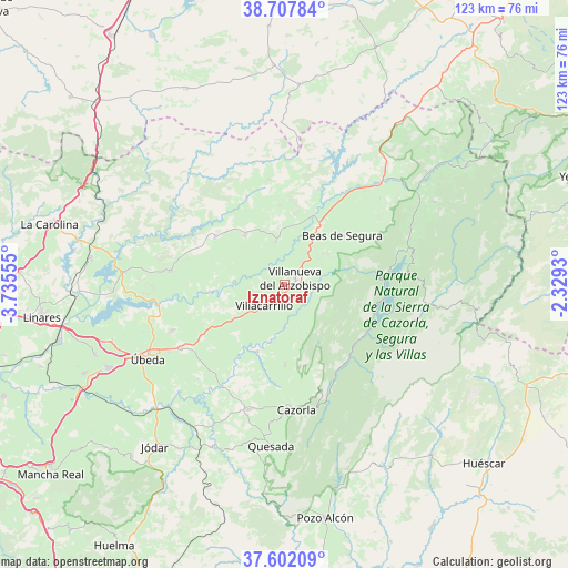
Iznatoraf GPS coordinates[2]
38° 9' 25.416" North, 3° 1' 56.712" West
| Map corner | latitude | longitude |
|---|---|---|
| Upper-left | 38.70784°, | -3.73555° |
| Center: | 38.15706°, | -3.03242° |
| Lower-right: | 37.60209°, | -2.3293° |
| Map W x H: | 122.9×122.9 km | = 76.4×76.4mi |
| max Lat: | 43.74134° ⇑87.4% North |
| Iznatoraf: | 38.15706° |
| min Lat: | ⇓12.6% South 27.64134° |
| min Long | Iznatoraf | max Long |
| -18.00367° | -3.03242° | 4.2899° |
| W 53.9%⇐ | ⇒46.1% E |
Elevation
Elevation of Iznatoraf is 1031 m = 3383 ft, and this is 433 m = 1421 ft above average elevation for this country.
| Max E: |
1682 m = 5518 ft | 10% |
| Iznatoraf | 1031 m 3383 ft | |
| Avg. | 598 m = 1962 ft | |
Min E: |
0 m = 0 ft | 90% |
See also: Spain elevation on elevation.city.
Geographical zone
Iznatoraf is located in North temperate zone (between Tropic of Cancer and the Arctic Circle). Distance of this Northern Tropic circle is 1636.7 km =1017 mi to South.| Distance of | km | miles | from Iznatoraf |
|---|---|---|---|
| North Pole | 5764.4 | 3581.8 | to North |
| Arctic Circle | 3158.5 | 1962.6 | to North |
| Tropic Cancer | 1636.7 | 1017 | to South |
| Equator | 4242.7 | 2636.3 | to South |


Nearby cities:
15 places around Iznatoraf: (largest is in red/bold)
• Arroyo del Ojanco
21.8 km =13.5 mi,  33°
33°
• Beas de Segura
16.4 km =10.2 mi,  49°
49°
• Benatae
9.6 km =6 mi,  291°
291°
• Campiña
8.2 km =5.1 mi, 33°
• Castellar de Santisteban
13.9 km =8.6 mi,  321°
321°
• Chiclana de Segura
17.2 km =10.7 mi,  357°
357°
• Chilluévar
17.4 km =10.8 mi,  179°
179°
• Montizón
21.5 km =13.4 mi,  343°
343°
• Navas de San Juan
25 km =15.5 mi,  276°
276°
• Santisteban del Puerto
18.4 km =11.4 mi,  303°
303°
• Santo Tomé
15.5 km =9.6 mi,  202°
202°
• Solana de Torralba
22.4 km =13.9 mi,  213°
213°
• Sorihuela del Guadalimar
9.5 km =5.9 mi,  348°
348°
• Villacarrillo
6.5 km =4 mi,  224°
224°
• Villanueva del Arzobispo
2.5 km =1.6 mi,  59°
59°
Sources, notices
• [Note1] Compared only with cities in Spain existing in our database
• [Src1] Map data: © OpenStreetMap contributors (CC-BY-SA)
• [Src2] Other city data from geonames.org with taken over terms of usage.
• [Src3] Geographical zone / Annual Mean Temperature by Robert A. Rohde @ Wikipedia
