Chilluévar geodata
Chilluévar (Andalusia) is a seat of a third-order administrative division; located in Spain in Europe/Madrid (GMT+2) time zone. With population of 1,693 people, there are 2343 cities with bigger population in this country. Compared to other cities in Spain, 88.6% of cities are located further ↑North; 53.9% of cities are located further ←West and 55.2% of cities have lower elevation than Chilluévar. Note1


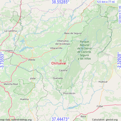
Chilluévar GPS coordinates[2]
38° 0' 3.168" North, 3° 1' 56.64" West
| Map corner | latitude | longitude |
|---|---|---|
| Upper-left | 38.55285°, | -3.73553° |
| Center: | 38.00088°, | -3.0324° |
| Lower-right: | 37.44473°, | -2.32928° |
| Map W x H: | 123.2×123.2 km | = 76.6×76.6mi |
| max Lat: | 43.74134° ⇑88.6% North |
| Chilluévar: | 38.00088° |
| min Lat: | ⇓11.4% South 27.64134° |
| min Long | Chilluévar | max Long |
| -18.00367° | -3.0324° | 4.2899° |
| W 53.9%⇐ | ⇒46.1% E |
Elevation
Elevation of Chilluévar is 710 m = 2329 ft, and this is 112 m = 367 ft above average elevation for this country.
| Max E: |
1682 m = 5518 ft | 44.8% |
| Chilluévar | 710 m 2329 ft | |
| Avg. | 598 m = 1962 ft | |
Min E: |
0 m = 0 ft | 55.2% |
See also: Spain elevation on elevation.city.
Geographical zone
Chilluévar is located in North temperate zone (between Tropic of Cancer and the Arctic Circle). Distance of this Northern Tropic circle is 1619.4 km =1006.2 mi to South.| Distance of | km | miles | from Chilluévar |
|---|---|---|---|
| North Pole | 5781.8 | 3592.6 | to North |
| Arctic Circle | 3175.9 | 1973.4 | to North |
| Tropic Cancer | 1619.4 | 1006.2 | to South |
| Equator | 4225.3 | 2625.5 | to South |


Nearby cities:
15 places around Chilluévar: (largest is in red/bold)
• Benatae
22.8 km =14.2 mi,  336°
336°
• Campiña
24.7 km =15.3 mi,  10°
10°
• Cazorla
9.9 km =6.2 mi,  165°
165°
• Hornos
18.7 km =11.6 mi,  227°
227°
• Huesa
26.6 km =16.5 mi,  188°
188°
• Iznatoraf
17.4 km =10.8 mi,  359°
359°
• La Iruela
9.5 km =5.9 mi,  160°
160°
• Peal de Becerro
12.5 km =7.8 mi,  218°
218°
• Quesada
17.8 km =11.1 mi, 189°
• Sabiote
25.8 km =16 mi,  287°
287°
• Santo Tomé
6.7 km =4.2 mi,  297°
297°
• Solana de Torralba
12.3 km =7.6 mi,  263°
263°
• Torreperogil
22.9 km =14.2 mi,  279°
279°
• Villacarrillo
13.6 km =8.5 mi, 340°
• Villanueva del Arzobispo
18.8 km =11.7 mi, 6°
Sources, notices
• [Note1] Compared only with cities in Spain existing in our database
• [Src1] Map data: © OpenStreetMap contributors (CC-BY-SA)
• [Src2] Other city data from geonames.org with taken over terms of usage.
• [Src3] Geographical zone / Annual Mean Temperature by Robert A. Rohde @ Wikipedia
