Santisteban del Puerto geodata
Santisteban del Puerto (Andalusia) is a seat of a third-order administrative division; located in Spain in Europe/Madrid (GMT+2) time zone. With population of 4,756 people, there are 1349 cities with bigger population in this country. Compared to other cities in Spain, 87% of cities are located further ↑North; 51.5% of cities are located further ←West and 54.7% of cities have lower elevation than Santisteban del Puerto. Note1
Administrative division(s):
- Level 1: Andalusia
- Level 2: Provincia de Jaén
- Level 3: Santisteban del Puerto
Current local time in Santisteban del Puerto:
10:40 PM, ThursdayDifference from your time zone: hours


Santisteban del Puerto GPS coordinates[2]
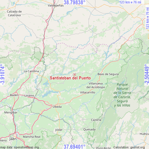
38° 14' 53.844" North, 3° 12' 27.432" West
| Map corner | latitude | longitude |
|---|---|---|
| Upper-left | 38.79838°, | -3.91074° |
| Center: | 38.24829°, | -3.20762° |
| Lower-right: | 37.69401°, | -2.50449° |
| Map W x H: | 122.8×122.8 km | = 76.3×76.3mi |
| max Lat: | 43.74134° ⇑87% North |
| Santisteban del Puerto: | 38.24829° |
| min Lat: | ⇓13% South 27.64134° |
| min Long | Santisteban del | max Long |
| -18.00367° | -3.20762° | 4.2899° |
| W 51.5%⇐ | ⇒48.5% E |
Elevation
Elevation of Santisteban del Puerto is 707 m = 2320 ft, and this is 109 m = 358 ft above average elevation for this country.
| Max E: |
1682 m = 5518 ft | 45.3% |
| Santisteban del Puerto | 707 m 2320 ft | |
| Avg. | 598 m = 1962 ft | |
Min E: |
0 m = 0 ft | 54.7% |
See also: Spain elevation on elevation.city.
Geographical zone
Santisteban del Puerto is located in North temperate zone (between Tropic of Cancer and the Arctic Circle). Distance of this Northern Tropic circle is 1646.9 km =1023.3 mi to South.| Distance of | km | miles | from Santisteban del Puerto |
|---|---|---|---|
| North Pole | 5754.3 | 3575.6 | to North |
| Arctic Circle | 3148.4 | 1956.3 | to North |
| Tropic Cancer | 1646.9 | 1023.3 | to South |
| Equator | 4252.8 | 2642.6 | to South |


Nearby cities:
15 places around Santisteban del Puerto: (largest is in red/bold)
• Aldeaquemada
23.2 km =14.4 mi,  321°
321°
• Arquillos
20.7 km =12.9 mi,  248°
248°
• Benatae
9.1 km =5.7 mi,  136°
136°
• Campiña
20.1 km =12.5 mi,  99°
99°
• Castellar de Santisteban
6.7 km =4.2 mi,  84°
84°
• Chiclana de Segura
16.1 km =10 mi,  63°
63°
• Iznatoraf
18.4 km =11.4 mi,  123°
123°
• Montizón
13.8 km =8.6 mi,  40°
40°
• Navas de San Juan
11.9 km =7.4 mi,  232°
232°
• Sabiote
22 km =13.7 mi,  205°
205°
• Santo Tomé
26.1 km =16.2 mi,  159°
159°
• Sorihuela del Guadalimar
13.5 km =8.4 mi,  93°
93°
• Torreperogil
24.7 km =15.3 mi,  196°
196°
• Villacarrillo
18.2 km =11.3 mi, 143°
• Villanueva del Arzobispo
19.6 km =12.2 mi, 116°
Sources, notices
• [Note1] Compared only with cities in Spain existing in our database
• [Src1] Map data: © OpenStreetMap contributors (CC-BY-SA)
• [Src2] Other city data from geonames.org with taken over terms of usage.
• [Src3] Geographical zone / Annual Mean Temperature by Robert A. Rohde @ Wikipedia
