Villacarrillo geodata
Villacarrillo (Andalusia) is a seat of a third-order administrative division; located in Spain in Europe/Madrid (GMT+2) time zone. With population of 11,294 people, there are 778 cities with bigger population in this country. Compared to other cities in Spain, 87.7% of cities are located further ↑North; 53% of cities are located further ←West and 68% of cities have lower elevation than Villacarrillo. Note1


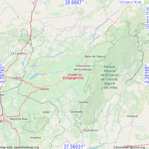
Villacarrillo GPS coordinates[2]
38° 6' 56.16" North, 3° 5' 5.28" West
| Map corner | latitude | longitude |
|---|---|---|
| Upper-left | 38.6667°, | -3.78793° |
| Center: | 38.1156°, | -3.0848° |
| Lower-right: | 37.56031°, | -2.38168° |
| Map W x H: | 123×123 km | = 76.4×76.4mi |
| max Lat: | 43.74134° ⇑87.7% North |
| Villacarrillo: | 38.1156° |
| min Lat: | ⇓12.3% South 27.64134° |
| min Long | Villacarrillo | max Long |
| -18.00367° | -3.0848° | 4.2899° |
| W 53%⇐ | ⇒47% E |
Elevation
Elevation of Villacarrillo is 799 m = 2621 ft, and this is 201 m = 659 ft above average elevation for this country.
| Max E: |
1682 m = 5518 ft | 32% |
| Villacarrillo | 799 m 2621 ft | |
| Avg. | 598 m = 1962 ft | |
Min E: |
0 m = 0 ft | 68% |
See also: Spain elevation on elevation.city.
Geographical zone
Villacarrillo is located in North temperate zone (between Tropic of Cancer and the Arctic Circle). Distance of this Northern Tropic circle is 1632.1 km =1014.1 mi to South.| Distance of | km | miles | from Villacarrillo |
|---|---|---|---|
| North Pole | 5769 | 3584.7 | to North |
| Arctic Circle | 3163.1 | 1965.5 | to North |
| Tropic Cancer | 1632.1 | 1014.1 | to South |
| Equator | 4238.1 | 2633.4 | to South |


Nearby cities:
15 places around Villacarrillo: (largest is in red/bold)
• Benatae
9.3 km =5.8 mi,  331°
331°
• Campiña
14.7 km =9.1 mi,  38°
38°
• Castellar de Santisteban
16 km =9.9 mi,  345°
345°
• Chiclana de Segura
22.1 km =13.7 mi,  9°
9°
• Chilluévar
13.6 km =8.5 mi,  160°
160°
• Iznatoraf
6.5 km =4 mi, 44°
• Navas de San Juan
21.6 km =13.4 mi,  290°
290°
• Peal de Becerro
22.7 km =14.1 mi,  188°
188°
• Sabiote
20.8 km =12.9 mi,  255°
255°
• Santisteban del Puerto
18.2 km =11.3 mi,  323°
323°
• Santo Tomé
9.8 km =6.1 mi, 188°
• Solana de Torralba
16.1 km =10 mi,  208°
208°
• Sorihuela del Guadalimar
14.2 km =8.8 mi, 11°
• Torreperogil
20.1 km =12.5 mi,  243°
243°
• Villanueva del Arzobispo
9 km =5.6 mi,  49°
49°
Sources, notices
• [Note1] Compared only with cities in Spain existing in our database
• [Src1] Map data: © OpenStreetMap contributors (CC-BY-SA)
• [Src2] Other city data from geonames.org with taken over terms of usage.
• [Src3] Geographical zone / Annual Mean Temperature by Robert A. Rohde @ Wikipedia
