Santo Tomé geodata
Santo Tomé (Andalusia) is a seat of a third-order administrative division; located in Spain in Europe/Madrid (GMT+2) time zone. With population of 2,273 people, there are 2013 cities with bigger population in this country. Compared to other cities in Spain, 88.4% of cities are located further ↑North; 52.7% of cities are located further ←West and 65.5% of cities have higher elevation than Santo Tomé. Note1


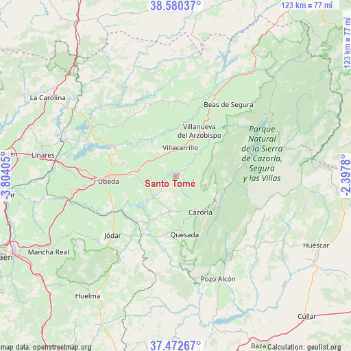
Santo Tomé GPS coordinates[2]
38° 1' 42.996" North, 3° 6' 3.312" West
| Map corner | latitude | longitude |
|---|---|---|
| Upper-left | 38.58037°, | -3.80405° |
| Center: | 38.02861°, | -3.10092° |
| Lower-right: | 37.47267°, | -2.3978° |
| Map W x H: | 123.2×123.2 km | = 76.6×76.6mi |
| max Lat: | 43.74134° ⇑88.4% North |
| Santo Tomé: | 38.02861° |
| min Lat: | ⇓11.6% South 27.64134° |
| min Long | Santo Tomé | max Long |
| -18.00367° | -3.10092° | 4.2899° |
| W 52.7%⇐ | ⇒47.3% E |
Elevation
Elevation of Santo Tomé is 454 m = 1490 ft, and this is 144 m = 472 ft below average elevation for this country.
| Max E: |
1682 m = 5518 ft | 65.5% |
| Avg. | 598 m = 1962 ft | |
| Santo Tomé | 454 m = 1490 ft | |
Min E: |
0 m = 0 ft | 34.5% |
See also: Spain elevation on elevation.city.
Geographical zone
Santo Tomé is located in North temperate zone (between Tropic of Cancer and the Arctic Circle). Distance of this Northern Tropic circle is 1622.5 km =1008.2 mi to South.| Distance of | km | miles | from Santo Tomé |
|---|---|---|---|
| North Pole | 5778.7 | 3590.7 | to North |
| Arctic Circle | 3172.8 | 1971.5 | to North |
| Tropic Cancer | 1622.5 | 1008.2 | to South |
| Equator | 4228.4 | 2627.4 | to South |


Nearby cities:
15 places around Santo Tomé: (largest is in red/bold)
• Benatae
18.1 km =11.2 mi,  350°
350°
• Campiña
23.6 km =14.7 mi,  26°
26°
• Cazorla
15.3 km =9.5 mi,  145°
145°
• Chilluévar
6.7 km =4.2 mi,  117°
117°
• Hornos
17.6 km =10.9 mi,  206°
206°
• Iznatoraf
15.5 km =9.6 mi,  22°
22°
• La Iruela
15.2 km =9.4 mi,  142°
142°
• Peal de Becerro
12.9 km =8 mi,  188°
188°
• Quesada
20.8 km =12.9 mi,  171°
171°
• Sabiote
19.2 km =11.9 mi,  283°
283°
• Solana de Torralba
7.7 km =4.8 mi,  234°
234°
• Torreperogil
16.6 km =10.3 mi,  272°
272°
• Villacarrillo
9.8 km =6.1 mi,  8°
8°
• Villanueva del Arzobispo
17.6 km =10.9 mi, 27°
• Úbeda
23.7 km =14.7 mi, 265°
Sources, notices
• [Note1] Compared only with cities in Spain existing in our database
• [Src1] Map data: © OpenStreetMap contributors (CC-BY-SA)
• [Src2] Other city data from geonames.org with taken over terms of usage.
• [Src3] Geographical zone / Annual Mean Temperature by Robert A. Rohde @ Wikipedia
