Huesa geodata
Huesa (Andalusia) is a populated place; located in Spain in Europe/Madrid (GMT+2) time zone. With population of 2,734 people, there are 1807 cities with bigger population in this country. Compared to other cities in Spain, 89.8% of cities are located further ↑North; 53.1% of cities are located further ←West and 51.4% of cities have higher elevation than Huesa. Note1


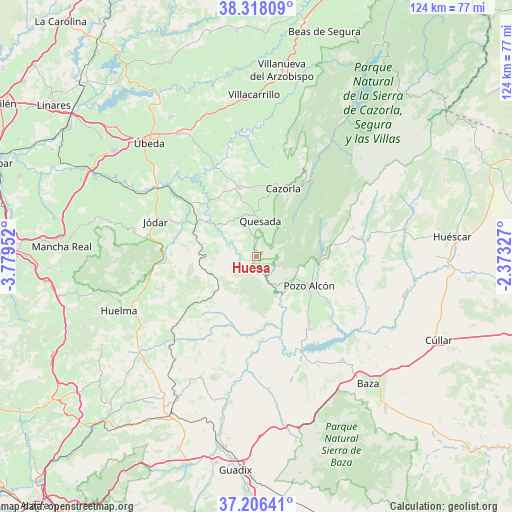
Huesa GPS coordinates[2]
37° 45' 51.624" North, 3° 4' 35.004" West
| Map corner | latitude | longitude |
|---|---|---|
| Upper-left | 38.31809°, | -3.77952° |
| Center: | 37.76434°, | -3.07639° |
| Lower-right: | 37.20641°, | -2.37327° |
| Map W x H: | 123.6×123.6 km | = 76.8×76.8mi |
| max Lat: | 43.74134° ⇑89.8% North |
| Huesa: | 37.76434° |
| min Lat: | ⇓10.2% South 27.64134° |
| min Long | Huesa | max Long |
| -18.00367° | -3.07639° | 4.2899° |
| W 53.1%⇐ | ⇒46.9% E |
Elevation
Elevation of Huesa is 644 m = 2113 ft, and this is 46 m = 151 ft above average elevation for this country.
| Max E: |
1682 m = 5518 ft | 51.4% |
| Huesa | 644 m 2113 ft | |
| Avg. | 598 m = 1962 ft | |
Min E: |
0 m = 0 ft | 48.6% |
See also: Spain elevation on elevation.city.
Geographical zone
Huesa is located in North temperate zone (between Tropic of Cancer and the Arctic Circle). Distance of this Northern Tropic circle is 1593.1 km =989.9 mi to South.| Distance of | km | miles | from Huesa |
|---|---|---|---|
| North Pole | 5808.1 | 3609 | to North |
| Arctic Circle | 3202.2 | 1989.8 | to North |
| Tropic Cancer | 1593.1 | 989.9 | to South |
| Equator | 4199 | 2609.1 | to South |


Nearby cities:
15 places around Huesa: (largest is in red/bold)
• Alamedilla
25 km =15.5 mi,  215°
215°
• Alicún de Ortega
18.1 km =11.2 mi,  197°
197°
• Cabra del Santo Cristo
19.8 km =12.3 mi,  250°
250°
• Cazorla
17.9 km =11.1 mi,  20°
20°
• Cuevas del Campo
21.7 km =13.5 mi,  143°
143°
• Dehesas de Guadix
19.7 km =12.2 mi,  186°
186°
• Hinojares
8.8 km =5.5 mi,  127°
127°
• Hornos
16.8 km =10.4 mi,  323°
323°
• Jódar
25.7 km =16 mi,  289°
289°
• La Iruela
18.7 km =11.6 mi, 22°
• Larva
11.1 km =6.9 mi,  267°
267°
• Peal de Becerro
17 km =10.6 mi,  346°
346°
• Pozo Alcón
14.3 km =8.9 mi,  118°
118°
• Quesada
8.8 km =5.5 mi,  6°
6°
• Villanueva de las Torres
23.1 km =14.4 mi,  182°
182°
Sources, notices
• [Note1] Compared only with cities in Spain existing in our database
• [Src1] Map data: © OpenStreetMap contributors (CC-BY-SA)
• [Src2] Other city data from geonames.org with taken over terms of usage.
• [Src3] Geographical zone / Annual Mean Temperature by Robert A. Rohde @ Wikipedia
