La Iruela geodata
La Iruela (Andalusia) is a populated place; located in Spain in Europe/Madrid (GMT+2) time zone. With population of 1,824 people, there are 2274 cities with bigger population in this country. Compared to other cities in Spain, 89% of cities are located further ↑North; 54.6% of cities are located further ←West and 78.8% of cities have lower elevation than La Iruela. Note1


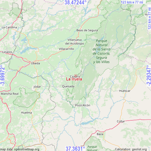
La Iruela GPS coordinates[2]
37° 55' 11.496" North, 2° 59' 47.724" West
| Map corner | latitude | longitude |
|---|---|---|
| Upper-left | 38.47244°, | -3.69972° |
| Center: | 37.91986°, | -2.99659° |
| Lower-right: | 37.3631°, | -2.29347° |
| Map W x H: | 123.3×123.3 km | = 76.6×76.6mi |
| max Lat: | 43.74134° ⇑89% North |
| La Iruela: | 37.91986° |
| min Lat: | ⇓11% South 27.64134° |
| min Long | La Iruela | max Long |
| -18.00367° | -2.99659° | 4.2899° |
| W 54.6%⇐ | ⇒45.4% E |
Elevation
Elevation of La Iruela is 886 m = 2907 ft, and this is 288 m = 945 ft above average elevation for this country.
| Max E: |
1682 m = 5518 ft | 21.2% |
| La Iruela | 886 m 2907 ft | |
| Avg. | 598 m = 1962 ft | |
Min E: |
0 m = 0 ft | 78.8% |
See also: Spain elevation on elevation.city.
Geographical zone
La Iruela is located in North temperate zone (between Tropic of Cancer and the Arctic Circle). Distance of this Northern Tropic circle is 1610.4 km =1000.7 mi to South.| Distance of | km | miles | from La Iruela |
|---|---|---|---|
| North Pole | 5790.8 | 3598.2 | to North |
| Arctic Circle | 3184.9 | 1979 | to North |
| Tropic Cancer | 1610.4 | 1000.7 | to South |
| Equator | 4216.3 | 2619.9 | to South |


Nearby cities:
15 places around La Iruela: (largest is in red/bold)
• Castril
23.5 km =14.6 mi,  125°
125°
• Cazorla
0.8 km =0.5 mi,  227°
227°
• Chilluévar
9.5 km =5.9 mi,  340°
340°
• Hinojares
22.7 km =14.1 mi,  180°
180°
• Hornos
17.3 km =10.7 mi,  257°
257°
• Huesa
18.7 km =11.6 mi,  202°
202°
• Iznatoraf
26.6 km =16.5 mi,  353°
353°
• Larva
25.3 km =15.7 mi, 225°
• Peal de Becerro
11 km =6.8 mi,  266°
266°
• Pozo Alcón
24.8 km =15.4 mi,  167°
167°
• Quesada
10.4 km =6.5 mi,  215°
215°
• Santo Tomé
15.2 km =9.4 mi,  322°
322°
• Solana de Torralba
17.2 km =10.7 mi,  296°
296°
• Villacarrillo
23.1 km =14.4 mi, 340°
• Villanueva del Arzobispo
27.7 km =17.2 mi,  358°
358°
Sources, notices
• [Note1] Compared only with cities in Spain existing in our database
• [Src1] Map data: © OpenStreetMap contributors (CC-BY-SA)
• [Src2] Other city data from geonames.org with taken over terms of usage.
• [Src3] Geographical zone / Annual Mean Temperature by Robert A. Rohde @ Wikipedia
