Peal de Becerro geodata
Peal de Becerro (Andalusia) is a populated place; located in Spain in Europe/Madrid (GMT+2) time zone. With population of 5,484 people, there are 1217 cities with bigger population in this country. Compared to other cities in Spain, 89% of cities are located further ↑North; 52.5% of cities are located further ←West and 58.3% of cities have higher elevation than Peal de Becerro. Note1


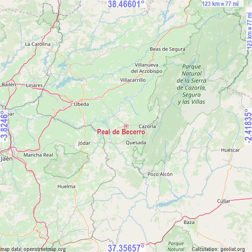
Peal de Becerro GPS coordinates[2]
37° 54' 48.168" North, 3° 7' 17.328" West
| Map corner | latitude | longitude |
|---|---|---|
| Upper-left | 38.46601°, | -3.8246° |
| Center: | 37.91338°, | -3.12148° |
| Lower-right: | 37.35657°, | -2.41835° |
| Map W x H: | 123.4×123.4 km | = 76.7×76.7mi |
| max Lat: | 43.74134° ⇑89% North |
| Peal de Becerro: | 37.91338° |
| min Lat: | ⇓11% South 27.64134° |
| min Long | Peal de Becerro | max Long |
| -18.00367° | -3.12148° | 4.2899° |
| W 52.5%⇐ | ⇒47.5% E |
Elevation
Elevation of Peal de Becerro is 549 m = 1801 ft, and this is 49 m = 161 ft below average elevation for this country.
| Max E: |
1682 m = 5518 ft | 58.3% |
| Avg. | 598 m = 1962 ft | |
| Peal de Becerro | 549 m = 1801 ft | |
Min E: |
0 m = 0 ft | 41.7% |
See also: Spain elevation on elevation.city.
Geographical zone
Peal de Becerro is located in North temperate zone (between Tropic of Cancer and the Arctic Circle). Distance of this Northern Tropic circle is 1609.7 km =1000.2 mi to South.| Distance of | km | miles | from Peal de Becerro |
|---|---|---|---|
| North Pole | 5791.5 | 3598.7 | to North |
| Arctic Circle | 3185.6 | 1979.4 | to North |
| Tropic Cancer | 1609.7 | 1000.2 | to South |
| Equator | 4215.6 | 2619.5 | to South |


Nearby cities:
15 places around Peal de Becerro: (largest is in red/bold)
• Cazorla
10.4 km =6.5 mi,  89°
89°
• Chilluévar
12.5 km =7.8 mi,  38°
38°
• Hinojares
24.5 km =15.2 mi,  153°
153°
• Hornos
6.6 km =4.1 mi,  243°
243°
• Huesa
17 km =10.6 mi,  166°
166°
• Jódar
21.8 km =13.5 mi,  248°
248°
• La Iruela
11 km =6.8 mi, 86°
• Larva
18.4 km =11.4 mi,  202°
202°
• Quesada
9.2 km =5.7 mi, 147°
• Sabiote
24.2 km =15 mi,  315°
315°
• Santo Tomé
12.9 km =8 mi,  8°
8°
• Solana de Torralba
9.4 km =5.8 mi,  332°
332°
• Torreperogil
20.1 km =12.5 mi,  312°
312°
• Villacarrillo
22.7 km =14.1 mi, 8°
• Úbeda
24.5 km =15.2 mi,  296°
296°
Sources, notices
• [Note1] Compared only with cities in Spain existing in our database
• [Src1] Map data: © OpenStreetMap contributors (CC-BY-SA)
• [Src2] Other city data from geonames.org with taken over terms of usage.
• [Src3] Geographical zone / Annual Mean Temperature by Robert A. Rohde @ Wikipedia
