Hornos geodata
Hornos (Andalusia) is a populated place; located in Spain in Europe/Madrid (GMT+2) time zone. With population of 620 people, there are 3569 cities with bigger population in this country. Compared to other cities in Spain, 89.2% of cities are located further ↑North; 51.8% of cities are located further ←West and 66.2% of cities have higher elevation than Hornos. Note1


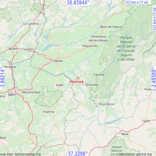
Hornos GPS coordinates[2]
37° 53' 11.796" North, 3° 11' 20.436" West
| Map corner | latitude | longitude |
|---|---|---|
| Upper-left | 38.43944°, | -3.89214° |
| Center: | 37.88661°, | -3.18901° |
| Lower-right: | 37.3296°, | -2.48589° |
| Map W x H: | 123.4×123.4 km | = 76.7×76.7mi |
| max Lat: | 43.74134° ⇑89.2% North |
| Hornos: | 37.88661° |
| min Lat: | ⇓10.8% South 27.64134° |
| min Long | Hornos | max Long |
| -18.00367° | -3.18901° | 4.2899° |
| W 51.8%⇐ | ⇒48.2% E |
Elevation
Elevation of Hornos is 444 m = 1457 ft, and this is 154 m = 505 ft below average elevation for this country.
| Max E: |
1682 m = 5518 ft | 66.2% |
| Avg. | 598 m = 1962 ft | |
| Hornos | 444 m = 1457 ft | |
Min E: |
0 m = 0 ft | 33.8% |
See also: Spain elevation on elevation.city.
Geographical zone
Hornos is located in North temperate zone (between Tropic of Cancer and the Arctic Circle). Distance of this Northern Tropic circle is 1606.7 km =998.4 mi to South.| Distance of | km | miles | from Hornos |
|---|---|---|---|
| North Pole | 5794.5 | 3600.5 | to North |
| Arctic Circle | 3188.6 | 1981.3 | to North |
| Tropic Cancer | 1606.7 | 998.4 | to South |
| Equator | 4212.6 | 2617.6 | to South |


Nearby cities:
15 places around Hornos: (largest is in red/bold)
• Bélmez de la Moraleda
24.8 km =15.4 mi,  223°
223°
• Cabra del Santo Cristo
22.1 km =13.7 mi,  203°
203°
• Cazorla
16.6 km =10.3 mi,  79°
79°
• Chilluévar
18.7 km =11.6 mi,  47°
47°
• Huesa
16.8 km =10.4 mi,  143°
143°
• Jódar
15.2 km =9.4 mi,  250°
250°
• La Iruela
17.3 km =10.7 mi, 77°
• Larva
14.1 km =8.8 mi,  184°
184°
• Peal de Becerro
6.6 km =4.1 mi,  63°
63°
• Quesada
11.9 km =7.4 mi,  113°
113°
• Sabiote
23.1 km =14.4 mi,  331°
331°
• Santo Tomé
17.6 km =10.9 mi,  26°
26°
• Solana de Torralba
11.4 km =7.1 mi,  7°
7°
• Torreperogil
18.8 km =11.7 mi, 331°
• Úbeda
21.3 km =13.2 mi,  311°
311°
Sources, notices
• [Note1] Compared only with cities in Spain existing in our database
• [Src1] Map data: © OpenStreetMap contributors (CC-BY-SA)
• [Src2] Other city data from geonames.org with taken over terms of usage.
• [Src3] Geographical zone / Annual Mean Temperature by Robert A. Rohde @ Wikipedia
