Larva geodata
Larva (Andalusia) is a seat of a third-order administrative division; located in Spain in Europe/Madrid (GMT+2) time zone. With population of 491 people, there are 3912 cities with bigger population in this country. Compared to other cities in Spain, 89.8% of cities are located further ↑North; 51.6% of cities are located further ←West and 55% of cities have lower elevation than Larva. Note1


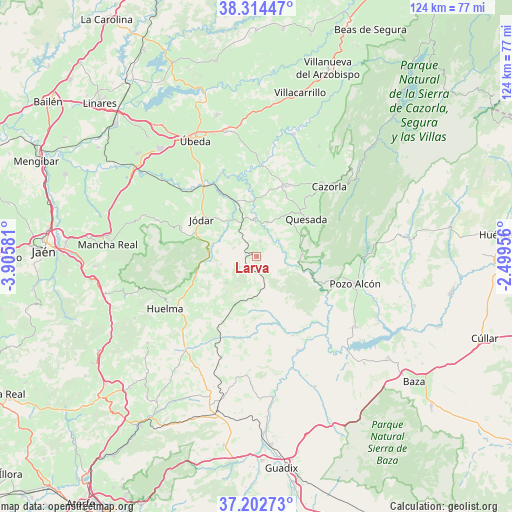
Larva GPS coordinates[2]
37° 45' 38.484" North, 3° 12' 9.684" West
| Map corner | latitude | longitude |
|---|---|---|
| Upper-left | 38.31447°, | -3.90581° |
| Center: | 37.76069°, | -3.20269° |
| Lower-right: | 37.20273°, | -2.49956° |
| Map W x H: | 123.6×123.6 km | = 76.8×76.8mi |
| max Lat: | 43.74134° ⇑89.8% North |
| Larva: | 37.76069° |
| min Lat: | ⇓10.2% South 27.64134° |
| min Long | Larva | max Long |
| -18.00367° | -3.20269° | 4.2899° |
| W 51.6%⇐ | ⇒48.4% E |
Elevation
Elevation of Larva is 709 m = 2326 ft, and this is 111 m = 364 ft above average elevation for this country.
| Max E: |
1682 m = 5518 ft | 45% |
| Larva | 709 m 2326 ft | |
| Avg. | 598 m = 1962 ft | |
Min E: |
0 m = 0 ft | 55% |
See also: Spain elevation on elevation.city.
Geographical zone
Larva is located in North temperate zone (between Tropic of Cancer and the Arctic Circle). Distance of this Northern Tropic circle is 1592.7 km =989.7 mi to South.| Distance of | km | miles | from Larva |
|---|---|---|---|
| North Pole | 5808.5 | 3609.2 | to North |
| Arctic Circle | 3202.6 | 1990 | to North |
| Tropic Cancer | 1592.7 | 989.7 | to South |
| Equator | 4198.6 | 2608.9 | to South |


Nearby cities:
15 places around Larva: (largest is in red/bold)
• Alamedilla
20.1 km =12.5 mi,  189°
189°
• Alicún de Ortega
17.8 km =11.1 mi,  160°
160°
• Bélmez de la Moraleda
16.3 km =10.1 mi,  255°
255°
• Cabra del Santo Cristo
9.8 km =6.1 mi,  229°
229°
• Cazorla
24.5 km =15.2 mi,  45°
45°
• Dehesas de Guadix
21 km =13 mi, 155°
• Hinojares
18.7 km =11.6 mi,  105°
105°
• Hornos
14.1 km =8.8 mi,  4°
4°
• Huesa
11.1 km =6.9 mi,  87°
87°
• Jódar
15.9 km =9.9 mi,  304°
304°
• La Iruela
25.3 km =15.7 mi, 45°
• Peal de Becerro
18.4 km =11.4 mi,  22°
22°
• Pozo Alcón
24.5 km =15.2 mi, 105°
• Quesada
15.2 km =9.4 mi, 52°
• Villanueva de las Torres
24.8 km =15.4 mi, 156°
Sources, notices
• [Note1] Compared only with cities in Spain existing in our database
• [Src1] Map data: © OpenStreetMap contributors (CC-BY-SA)
• [Src2] Other city data from geonames.org with taken over terms of usage.
• [Src3] Geographical zone / Annual Mean Temperature by Robert A. Rohde @ Wikipedia
