Hontanar geodata
Hontanar (Castille-La Mancha) is a seat of a third-order administrative division; located in Spain in Europe/Madrid (GMT+2) time zone. With population of 148 people, there are 5444 cities with bigger population in this country. Compared to other cities in Spain, 75.6% of cities are located further ↑North; 66.1% of cities are located further →East and 74.7% of cities have lower elevation than Hontanar. Note1
Administrative division(s):
- Level 1: Castille-La Mancha
- Level 2: Province of Toledo
- Level 3: Hontanar


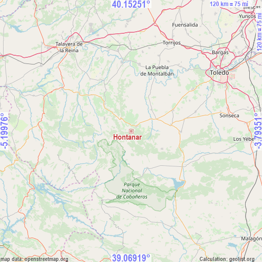
Hontanar GPS coordinates[2]
39° 36' 46.692" North, 4° 29' 47.868" West
| Map corner | latitude | longitude |
|---|---|---|
| Upper-left | 40.15251°, | -5.19976° |
| Center: | 39.61297°, | -4.49663° |
| Lower-right: | 39.06919°, | -3.79351° |
| Map W x H: | 120.5×120.5 km | = 74.9×74.9mi |
| max Lat: | 43.74134° ⇑75.6% North |
| Hontanar: | 39.61297° |
| min Lat: | ⇓24.4% South 27.64134° |
| min Long | Hontanar | max Long |
| -18.00367° | -4.49663° | 4.2899° |
| W 33.9%⇐ | ⇒66.1% E |
Elevation
Elevation of Hontanar is 849 m = 2785 ft, and this is 251 m = 823 ft above average elevation for this country.
| Max E: |
1682 m = 5518 ft | 25.3% |
| Hontanar | 849 m 2785 ft | |
| Avg. | 598 m = 1962 ft | |
Min E: |
0 m = 0 ft | 74.7% |
See also: Spain elevation on elevation.city.
Geographical zone
Hontanar is located in North temperate zone (between Tropic of Cancer and the Arctic Circle). Distance of this Northern Tropic circle is 1798.6 km =1117.6 mi to South.| Distance of | km | miles | from Hontanar |
|---|---|---|---|
| North Pole | 5602.5 | 3481.2 | to North |
| Arctic Circle | 2996.6 | 1862 | to North |
| Tropic Cancer | 1798.6 | 1117.6 | to South |
| Equator | 4404.5 | 2736.8 | to South |


Nearby cities:
15 places around Hontanar: (largest is in red/bold)
• Cuerva
25.1 km =15.6 mi,  77°
77°
• Espinoso del Rey
25 km =15.5 mi,  280°
280°
• Gálvez
21.6 km =13.4 mi,  62°
62°
• Los Navalmorales
17.6 km =10.9 mi,  315°
315°
• Los Navalucillos
13.8 km =8.6 mi,  295°
295°
• Menasalbas
18.4 km =11.4 mi, 80°
• Navahermosa
3.4 km =2.1 mi,  42°
42°
• Navas de Estena
13.3 km =8.3 mi,  189°
189°
• Retuerta de Bullaque
18.1 km =11.2 mi,  156°
156°
• San Martín de Montalbán
13.6 km =8.5 mi, 43°
• San Martín de Pusa
22.3 km =13.9 mi,  328°
328°
• Santa Ana de Pusa
24.6 km =15.3 mi,  312°
312°
• Totanés
25.5 km =15.8 mi, 64°
• Ventas con Peña Aguilera
22.7 km =14.1 mi,  90°
90°
• Villarejo de Montalbán
18.6 km =11.6 mi,  339°
339°
Sources, notices
• [Note1] Compared only with cities in Spain existing in our database
• [Src1] Map data: © OpenStreetMap contributors (CC-BY-SA)
• [Src2] Other city data from geonames.org with taken over terms of usage.
• [Src3] Geographical zone / Annual Mean Temperature by Robert A. Rohde @ Wikipedia
