Ríolobos geodata
Ríolobos (Extremadura) is a populated place; located in Spain in Europe/Madrid (GMT+2) time zone. With population of 1,330 people, there are 2614 cities with bigger population in this country. Compared to other cities in Spain, 71.3% of cities are located further ↑North; 89.5% of cities are located further →East and 77% of cities have higher elevation than Ríolobos. Note1


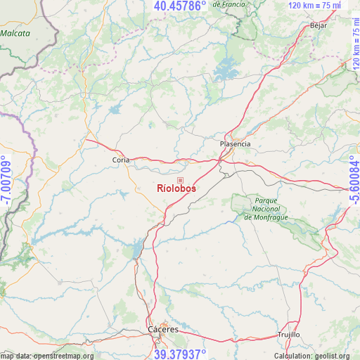
Ríolobos GPS coordinates[2]
39° 55' 14.664" North, 6° 18' 14.292" West
| Map corner | latitude | longitude |
|---|---|---|
| Upper-left | 40.45786°, | -7.00709° |
| Center: | 39.92074°, | -6.30397° |
| Lower-right: | 39.37937°, | -5.60084° |
| Map W x H: | 119.9×119.9 km | = 74.5×74.5mi |
| max Lat: | 43.74134° ⇑71.3% North |
| Ríolobos: | 39.92074° |
| min Lat: | ⇓28.7% South 27.64134° |
| min Long | Ríolobos | max Long |
| -18.00367° | -6.30397° | 4.2899° |
| W 10.5%⇐ | ⇒89.5% E |
Elevation
Elevation of Ríolobos is 269 m = 883 ft, and this is 329 m = 1079 ft below average elevation for this country.
| Max E: |
1682 m = 5518 ft | 77% |
| Avg. | 598 m = 1962 ft | |
| Ríolobos | 269 m = 883 ft | |
Min E: |
0 m = 0 ft | 23% |
See also: Spain elevation on elevation.city.
Geographical zone
Ríolobos is located in North temperate zone (between Tropic of Cancer and the Arctic Circle). Distance of this Northern Tropic circle is 1832.9 km =1138.9 mi to South.| Distance of | km | miles | from Ríolobos |
|---|---|---|---|
| North Pole | 5568.3 | 3460 | to North |
| Arctic Circle | 2962.4 | 1840.7 | to North |
| Tropic Cancer | 1832.9 | 1138.9 | to South |
| Equator | 4438.8 | 2758.1 | to South |


Nearby cities:
15 places around Ríolobos: (largest is in red/bold)
• Carcaboso
16.3 km =10.1 mi,  28°
28°
• Casas de Millán
11.7 km =7.3 mi,  190°
190°
• Cañaveral
16.1 km =10 mi,  207°
207°
• Coria
21 km =13 mi,  289°
289°
• Galisteo
6.9 km =4.3 mi, 26°
• Guijo de Galisteo
21.3 km =13.2 mi,  334°
334°
• Holguera
4.6 km =2.9 mi,  238°
238°
• Mirabel
8.9 km =5.5 mi,  136°
136°
• Montehermoso
19 km =11.8 mi,  348°
348°
• Morcillo
13.5 km =8.4 mi,  323°
323°
• Pedroso de Acim
14.1 km =8.8 mi,  221°
221°
• Portezuelo
18.9 km =11.7 mi,  230°
230°
• Serradilla
17.3 km =10.7 mi,  126°
126°
• Torrejoncillo
14.2 km =8.8 mi,  259°
259°
• Valdeobispo
18.7 km =11.6 mi,  14°
14°
Sources, notices
• [Note1] Compared only with cities in Spain existing in our database
• [Src1] Map data: © OpenStreetMap contributors (CC-BY-SA)
• [Src2] Other city data from geonames.org with taken over terms of usage.
• [Src3] Geographical zone / Annual Mean Temperature by Robert A. Rohde @ Wikipedia
