Holguera geodata
Holguera (Extremadura) is a seat of a third-order administrative division; located in Spain in Europe/Madrid (GMT+2) time zone. With population of 770 people, there are 3270 cities with bigger population in this country. Compared to other cities in Spain, 71.6% of cities are located further ↑North; 89.9% of cities are located further →East and 76.5% of cities have higher elevation than Holguera. Note1


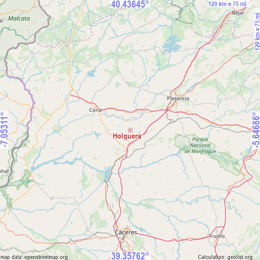
Holguera GPS coordinates[2]
39° 53' 56.976" North, 6° 20' 59.964" West
| Map corner | latitude | longitude |
|---|---|---|
| Upper-left | 40.43645°, | -7.05311° |
| Center: | 39.89916°, | -6.34999° |
| Lower-right: | 39.35762°, | -5.64686° |
| Map W x H: | 120×120 km | = 74.6×74.6mi |
| max Lat: | 43.74134° ⇑71.6% North |
| Holguera: | 39.89916° |
| min Lat: | ⇓28.4% South 27.64134° |
| min Long | Holguera | max Long |
| -18.00367° | -6.34999° | 4.2899° |
| W 10.1%⇐ | ⇒89.9% E |
Elevation
Elevation of Holguera is 278 m = 912 ft, and this is 320 m = 1050 ft below average elevation for this country.
| Max E: |
1682 m = 5518 ft | 76.5% |
| Avg. | 598 m = 1962 ft | |
| Holguera | 278 m = 912 ft | |
Min E: |
0 m = 0 ft | 23.5% |
See also: Spain elevation on elevation.city.
Geographical zone
Holguera is located in North temperate zone (between Tropic of Cancer and the Arctic Circle). Distance of this Northern Tropic circle is 1830.5 km =1137.4 mi to South.| Distance of | km | miles | from Holguera |
|---|---|---|---|
| North Pole | 5570.7 | 3461.5 | to North |
| Arctic Circle | 2964.8 | 1842.2 | to North |
| Tropic Cancer | 1830.5 | 1137.4 | to South |
| Equator | 4436.4 | 2756.7 | to South |


Nearby cities:
15 places around Holguera: (largest is in red/bold)
• Carcaboso
20.4 km =12.7 mi,  34°
34°
• Casas de Millán
9.2 km =5.7 mi,  169°
169°
• Cañaveral
12.4 km =7.7 mi,  196°
196°
• Coria
18.5 km =11.5 mi,  300°
300°
• Galisteo
11.1 km =6.9 mi,  39°
39°
• Mirabel
10.8 km =6.7 mi,  112°
112°
• Montehermoso
21 km =13 mi,  0°
0°
• Morcillo
13.9 km =8.6 mi,  343°
343°
• Pedroso de Acim
9.8 km =6.1 mi,  212°
212°
• Portaje
18.2 km =11.3 mi,  276°
276°
• Portezuelo
14.3 km =8.9 mi,  227°
227°
• Ríolobos
4.6 km =2.9 mi,  58°
58°
• Serradilla
19.5 km =12.1 mi, 113°
• Talaván
21.1 km =13.1 mi,  163°
163°
• Torrejoncillo
10 km =6.2 mi,  268°
268°
Sources, notices
• [Note1] Compared only with cities in Spain existing in our database
• [Src1] Map data: © OpenStreetMap contributors (CC-BY-SA)
• [Src2] Other city data from geonames.org with taken over terms of usage.
• [Src3] Geographical zone / Annual Mean Temperature by Robert A. Rohde @ Wikipedia
