Huelma geodata
Huelma (Andalusia) is a seat of a third-order administrative division; located in Spain in Europe/Madrid (GMT+2) time zone. With population of 6,159 people, there are 1115 cities with bigger population in this country. Compared to other cities in Spain, 90.4% of cities are located further ↑North; 51.5% of cities are located further →East and 88.4% of cities have lower elevation than Huelma. Note1


Huelma GPS coordinates[2]
37° 38' 52.224" North, 3° 27' 35.46" West
| Map corner | latitude | longitude |
|---|---|---|
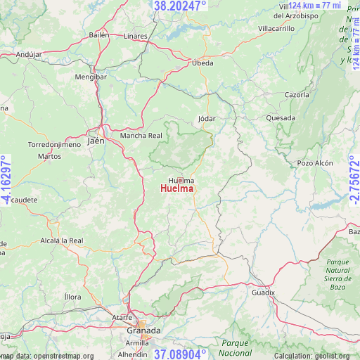
| Upper-left | 38.20247°, | -4.16297° |
| Center: | 37.64784°, | -3.45985° |
| Lower-right: | 37.08904°, | -2.75672° |
| Map W x H: | 123.8×123.8 km | = 76.9×76.9mi |
| max Lat: | 43.74134° ⇑90.4% North |
| Huelma: | 37.64784° |
| min Lat: | ⇓9.6% South 27.64134° |
| min Long | Huelma | max Long |
| -18.00367° | -3.45985° | 4.2899° |
| W 48.5%⇐ | ⇒51.5% E |
Elevation
Elevation of Huelma is 1004 m = 3294 ft, and this is 406 m = 1332 ft above average elevation for this country.
| Max E: |
1682 m = 5518 ft | 11.6% |
| Huelma | 1004 m 3294 ft | |
| Avg. | 598 m = 1962 ft | |
Min E: |
0 m = 0 ft | 88.4% |
See also: Spain elevation on elevation.city.
Geographical zone
Huelma is located in North temperate zone (between Tropic of Cancer and the Arctic Circle). Distance of this Northern Tropic circle is 1580.1 km =981.8 mi to South.| Distance of | km | miles | from Huelma |
|---|---|---|---|
| North Pole | 5821 | 3617 | to North |
| Arctic Circle | 3215.1 | 1997.8 | to North |
| Tropic Cancer | 1580.1 | 981.8 | to South |
| Equator | 4186 | 2601.1 | to South |


Nearby cities:
15 places around Huelma: (largest is in red/bold)
• Alamedilla
20.5 km =12.7 mi,  110°
110°
• Bélmez de la Moraleda
10.9 km =6.8 mi,  39°
39°
• Cabra del Santo Cristo
16.4 km =10.2 mi,  67°
67°
• Cambil
9.9 km =6.2 mi,  290°
290°
• Campillo de Arenas
18.6 km =11.6 mi,  236°
236°
• Dehesas Viejas
21 km =13 mi,  202°
202°
• Domingo Pérez
17.4 km =10.8 mi,  194°
194°
• Guadahortuna
11.4 km =7.1 mi,  151°
151°
• Jimena
21.6 km =13.4 mi,  355°
355°
• Mancha Real
20.4 km =12.7 mi,  318°
318°
• Montejicar
9.3 km =5.8 mi,  205°
205°
• Noalejo
21.7 km =13.5 mi,  232°
232°
• Pegalajar
19.6 km =12.2 mi,  301°
301°
• Torre-Cardela
18.4 km =11.4 mi, 150°
• Torres
15.9 km =9.9 mi,  344°
344°
Sources, notices
• [Note1] Compared only with cities in Spain existing in our database
• [Src1] Map data: © OpenStreetMap contributors (CC-BY-SA)
• [Src2] Other city data from geonames.org with taken over terms of usage.
• [Src3] Geographical zone / Annual Mean Temperature by Robert A. Rohde @ Wikipedia
