Ferreries geodata
Ferreries (Balearic Islands) is a seat of a third-order administrative division; located in Spain in Europe/Madrid (GMT+2) time zone. With population of 4,416 people, there are 1399 cities with bigger population in this country. Compared to other cities in Spain, 70.5% of cities are located further ↑North; 99.9% of cities are located further ←West and 89.8% of cities have higher elevation than Ferreries. Note1


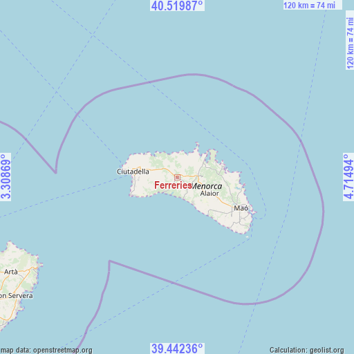
Ferreries GPS coordinates[2]
39° 58' 59.664" North, 4° 0' 42.516" East
| Map corner | latitude | longitude |
|---|---|---|
| Upper-left | 40.51987°, | 3.30869° |
| Center: | 39.98324°, | 4.01181° |
| Lower-right: | 39.44236°, | 4.71494° |
| Map W x H: | 119.8×119.8 km | = 74.4×74.4mi |
| max Lat: | 43.74134° ⇑70.5% North |
| Ferreries: | 39.98324° |
| min Lat: | ⇓29.5% South 27.64134° |
| min Long | Ferreries | max Long |
| -18.00367° | 4.01181° | 4.2899° |
| W 99.9%⇐ | ⇒0.099999999999994% E |
Elevation
Elevation of Ferreries is 70 m = 230 ft, and this is 528 m = 1732 ft below average elevation for this country.
| Max E: |
1682 m = 5518 ft | 89.8% |
| Avg. | 598 m = 1962 ft | |
| Ferreries | 70 m = 230 ft | |
Min E: |
0 m = 0 ft | 10.2% |
See also: Spain elevation on elevation.city.
Geographical zone
Ferreries is located in North temperate zone (between Tropic of Cancer and the Arctic Circle). Distance of this Northern Tropic circle is 1839.8 km =1143.2 mi to South.| Distance of | km | miles | from Ferreries |
|---|---|---|---|
| North Pole | 5561.3 | 3455.6 | to North |
| Arctic Circle | 2955.5 | 1836.5 | to North |
| Tropic Cancer | 1839.8 | 1143.2 | to South |
| Equator | 4445.7 | 2762.4 | to South |


Nearby cities:
15 places around Ferreries: (largest is in red/bold)
• Alaior
12.4 km =7.7 mi,  118°
118°
• Artà
65.1 km =40.5 mi,  240°
240°
• Cala Rajada
55.7 km =34.6 mi, 237°
• Can Picafort
77 km =47.8 mi,  251°
251°
• Capdepera
58.3 km =36.2 mi, 237°
• Ciutadella
14.6 km =9.1 mi,  277°
277°
• Es Castell
26.5 km =16.5 mi, 116°
• Es Migjorn Gran
5.3 km =3.3 mi,  140°
140°
• Maó
24.1 km =15 mi, 115°
• Mercadal
7 km =4.3 mi,  83°
83°
• Port d'Alcúdia
76.6 km =47.6 mi,  258°
258°
• Porto Cristo
76.2 km =47.3 mi,  229°
229°
• Sant Llorenç des Cardassar
74.8 km =46.5 mi, 236°
• Sant Lluís
25.7 km =16 mi,  125°
125°
• Son Servera
68.7 km =42.7 mi, 234°
Sources, notices
• [Note1] Compared only with cities in Spain existing in our database
• [Src1] Map data: © OpenStreetMap contributors (CC-BY-SA)
• [Src2] Other city data from geonames.org with taken over terms of usage.
• [Src3] Geographical zone / Annual Mean Temperature by Robert A. Rohde @ Wikipedia
