Alaior geodata
Alaior (Balearic Islands) is a seat of a third-order administrative division; located in Spain in Europe/Madrid (GMT+2) time zone. With population of 8,671 people, there are 906 cities with bigger population in this country. Compared to other cities in Spain, 71.2% of cities are located further ↑North; 100% of cities are located further ←West and 86.4% of cities have higher elevation than Alaior. Note1


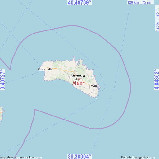
Alaior GPS coordinates[2]
39° 55' 49.224" North, 4° 8' 25.404" East
| Map corner | latitude | longitude |
|---|---|---|
| Upper-left | 40.46739°, | 3.43727° |
| Center: | 39.93034°, | 4.14039° |
| Lower-right: | 39.38904°, | 4.84352° |
| Map W x H: | 119.9×119.9 km | = 74.5×74.5mi |
| max Lat: | 43.74134° ⇑71.2% North |
| Alaior: | 39.93034° |
| min Lat: | ⇓28.8% South 27.64134° |
| min Long | Alaior | max Long |
| -18.00367° | 4.14039° | 4.2899° |
| W 100%⇐ | ⇒0% E |
Elevation
Elevation of Alaior is 117 m = 384 ft, and this is 481 m = 1578 ft below average elevation for this country.
| Max E: |
1682 m = 5518 ft | 86.4% |
| Avg. | 598 m = 1962 ft | |
| Alaior | 117 m = 384 ft | |
Min E: |
0 m = 0 ft | 13.6% |
See also: Spain elevation on elevation.city.
Geographical zone
Alaior is located in North temperate zone (between Tropic of Cancer and the Arctic Circle). Distance of this Northern Tropic circle is 1833.9 km =1139.5 mi to South.| Distance of | km | miles | from Alaior |
|---|---|---|---|
| North Pole | 5567.2 | 3459.3 | to North |
| Arctic Circle | 2961.3 | 1840.1 | to North |
| Tropic Cancer | 1833.9 | 1139.5 | to South |
| Equator | 4439.8 | 2758.8 | to South |


Nearby cities:
15 places around Alaior: (largest is in red/bold)
• Artà
72.5 km =45 mi,  248°
248°
• Cala Rajada
62.7 km =39 mi, 247°
• Can Picafort
86.1 km =53.5 mi,  257°
257°
• Capdepera
65.3 km =40.6 mi, 247°
• Ciutadella
26.7 km =16.6 mi,  287°
287°
• Es Castell
14 km =8.7 mi,  114°
114°
• Es Migjorn Gran
7.8 km =4.8 mi,  283°
283°
• Ferreries
12.4 km =7.7 mi,  298°
298°
• Maó
11.7 km =7.3 mi, 113°
• Mercadal
7.7 km =4.8 mi,  329°
329°
• Port d'Alcúdia
86.5 km =53.7 mi, 263°
• Porto Cristo
81.6 km =50.7 mi,  237°
237°
• Sant Llorenç des Cardassar
81.4 km =50.6 mi, 244°
• Sant Lluís
13.5 km =8.4 mi,  131°
131°
• Son Servera
75 km =46.6 mi, 242°
Sources, notices
• [Note1] Compared only with cities in Spain existing in our database
• [Src1] Map data: © OpenStreetMap contributors (CC-BY-SA)
• [Src2] Other city data from geonames.org with taken over terms of usage.
• [Src3] Geographical zone / Annual Mean Temperature by Robert A. Rohde @ Wikipedia
