Capdepera geodata
Capdepera (Balearic Islands) is a seat of a third-order administrative division; located in Spain in Europe/Madrid (GMT+2) time zone. With population of 11,911 people, there are 752 cities with bigger population in this country. Compared to other cities in Spain, 74.3% of cities are located further ↑North; 99.9% of cities are located further ←West and 88.1% of cities have higher elevation than Capdepera. Note1


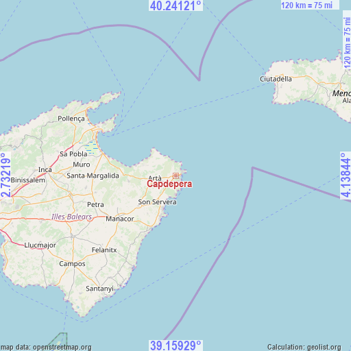
Capdepera GPS coordinates[2]
39° 42' 8.532" North, 3° 26' 7.152" East
| Map corner | latitude | longitude |
|---|---|---|
| Upper-left | 40.24121°, | 2.73219° |
| Center: | 39.70237°, | 3.43532° |
| Lower-right: | 39.15929°, | 4.13844° |
| Map W x H: | 120.3×120.3 km | = 74.8×74.8mi |
| max Lat: | 43.74134° ⇑74.3% North |
| Capdepera: | 39.70237° |
| min Lat: | ⇓25.7% South 27.64134° |
| min Long | Capdepera | max Long |
| -18.00367° | 3.43532° | 4.2899° |
| W 99.9%⇐ | ⇒0.099999999999994% E |
Elevation
Elevation of Capdepera is 94 m = 308 ft, and this is 504 m = 1654 ft below average elevation for this country.
| Max E: |
1682 m = 5518 ft | 88.1% |
| Avg. | 598 m = 1962 ft | |
| Capdepera | 94 m = 308 ft | |
Min E: |
0 m = 0 ft | 11.9% |
See also: Spain elevation on elevation.city.
Geographical zone
Capdepera is located in North temperate zone (between Tropic of Cancer and the Arctic Circle). Distance of this Northern Tropic circle is 1808.6 km =1123.8 mi to South.| Distance of | km | miles | from Capdepera |
|---|---|---|---|
| North Pole | 5592.6 | 3475.1 | to North |
| Arctic Circle | 2986.7 | 1855.8 | to North |
| Tropic Cancer | 1808.6 | 1123.8 | to South |
| Equator | 4414.5 | 2743 | to South |


Nearby cities:
15 places around Capdepera: (largest is in red/bold)
• Alcúdia
31.6 km =19.6 mi,  302°
302°
• Ariany
28.4 km =17.6 mi,  258°
258°
• Artà
7.4 km =4.6 mi, 262°
• Cala Rajada
2.6 km =1.6 mi,  66°
66°
• Can Picafort
25 km =15.5 mi,  286°
286°
• Manacor
24.3 km =15.1 mi,  232°
232°
• Maria de la Salut
31.3 km =19.4 mi, 261°
• Muro
32.7 km =20.3 mi,  276°
276°
• Petra
29.3 km =18.2 mi,  250°
250°
• Port d'Alcúdia
30.1 km =18.7 mi, 300°
• Porto Cristo
20.1 km =12.5 mi,  205°
205°
• Sant Llorenç des Cardassar
16.5 km =10.3 mi, 231°
• Santa Margalida
28.5 km =17.7 mi,  269°
269°
• Son Servera
11.1 km =6.9 mi,  215°
215°
• Vilafranca de Bonany
33.2 km =20.6 mi,  243°
243°
Sources, notices
• [Note1] Compared only with cities in Spain existing in our database
• [Src1] Map data: © OpenStreetMap contributors (CC-BY-SA)
• [Src2] Other city data from geonames.org with taken over terms of usage.
• [Src3] Geographical zone / Annual Mean Temperature by Robert A. Rohde @ Wikipedia
