Ciutadella geodata
Ciutadella (Balearic Islands) is a seat of a third-order administrative division; located in Spain in Europe/Madrid (GMT+2) time zone. With population of 29,160 people, there are 319 cities with bigger population in this country. Compared to other cities in Spain, 70.2% of cities are located further ↑North; 99.9% of cities are located further ←West and 95.6% of cities have higher elevation than Ciutadella. Note1
Administrative division(s):
- Level 1: Balearic Islands
- Level 2: Illes Balears
- Level 3: Ciutadella de Menorca


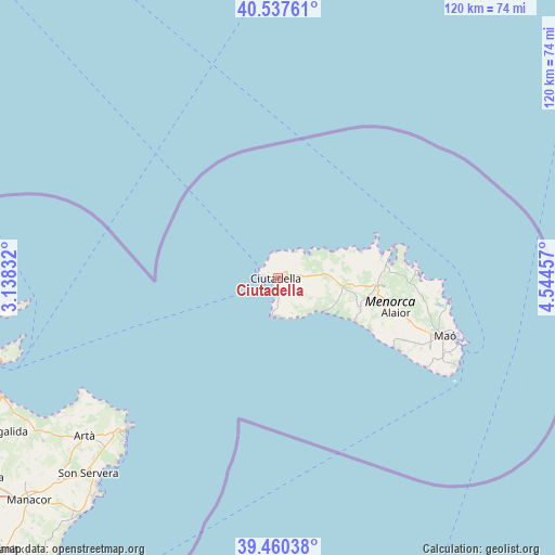
Ciutadella GPS coordinates[2]
40° 0' 4.032" North, 3° 50' 29.184" East
| Map corner | latitude | longitude |
|---|---|---|
| Upper-left | 40.53761°, | 3.13832° |
| Center: | 40.00112°, | 3.84144° |
| Lower-right: | 39.46038°, | 4.54457° |
| Map W x H: | 119.8×119.8 km | = 74.4×74.4mi |
| max Lat: | 43.74134° ⇑70.2% North |
| Ciutadella: | 40.00112° |
| min Lat: | ⇓29.8% South 27.64134° |
| min Long | Ciutadella | max Long |
| -18.00367° | 3.84144° | 4.2899° |
| W 99.9%⇐ | ⇒0.099999999999994% E |
Elevation
Elevation of Ciutadella is 22 m = 72 ft, and this is 576 m = 1890 ft below average elevation for this country.
| Max E: |
1682 m = 5518 ft | 95.6% |
| Avg. | 598 m = 1962 ft | |
| Ciutadella | 22 m = 72 ft | |
Min E: |
0 m = 0 ft | 4.4% |
See also: Spain elevation on elevation.city.
Geographical zone
Ciutadella is located in North temperate zone (between Tropic of Cancer and the Arctic Circle). Distance of this Northern Tropic circle is 1841.8 km =1144.4 mi to South.| Distance of | km | miles | from Ciutadella |
|---|---|---|---|
| North Pole | 5559.4 | 3454.4 | to North |
| Arctic Circle | 2953.5 | 1835.2 | to North |
| Tropic Cancer | 1841.8 | 1144.4 | to South |
| Equator | 4447.7 | 2763.7 | to South |


Nearby cities:
15 places around Ciutadella: (largest is in red/bold)
• Alaior
26.7 km =16.6 mi,  107°
107°
• Alcúdia
63.6 km =39.5 mi,  254°
254°
• Artà
54.2 km =33.7 mi,  230°
230°
• Cala Rajada
45.6 km =28.3 mi, 225°
• Can Picafort
64.2 km =39.9 mi, 245°
• Capdepera
48 km =29.8 mi, 226°
• Es Castell
40.6 km =25.2 mi, 109°
• Es Migjorn Gran
18.9 km =11.7 mi, 108°
• Ferreries
14.6 km =9.1 mi,  97°
97°
• Maó
38.3 km =23.8 mi, 109°
• Mercadal
21.5 km =13.4 mi,  93°
93°
• Port d'Alcúdia
63 km =39.1 mi, 253°
• Sant Llorenç des Cardassar
64.5 km =40.1 mi, 227°
• Sant Lluís
39.3 km =24.4 mi,  115°
115°
• Son Servera
59 km =36.7 mi,  224°
224°
Sources, notices
• [Note1] Compared only with cities in Spain existing in our database
• [Src1] Map data: © OpenStreetMap contributors (CC-BY-SA)
• [Src2] Other city data from geonames.org with taken over terms of usage.
• [Src3] Geographical zone / Annual Mean Temperature by Robert A. Rohde @ Wikipedia
