Artà geodata
Artà (Balearic Islands) is a seat of a third-order administrative division; located in Spain in Europe/Madrid (GMT+2) time zone. With population of 6,649 people, there are 1072 cities with bigger population in this country. Compared to other cities in Spain, 74.6% of cities are located further ↑North; 99.8% of cities are located further ←West and 85.7% of cities have higher elevation than Artà. Note1


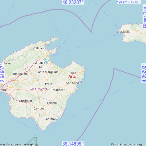
Artà GPS coordinates[2]
39° 41' 35.34" North, 3° 20' 59.244" East
| Map corner | latitude | longitude |
|---|---|---|
| Upper-left | 40.23207°, | 2.64667° |
| Center: | 39.69315°, | 3.34979° |
| Lower-right: | 39.14999°, | 4.05292° |
| Map W x H: | 120.3×120.3 km | = 74.8×74.8mi |
| max Lat: | 43.74134° ⇑74.6% North |
| Artà: | 39.69315° |
| min Lat: | ⇓25.4% South 27.64134° |
| min Long | Artà | max Long |
| -18.00367° | 3.34979° | 4.2899° |
| W 99.8%⇐ | ⇒0.2% E |
Elevation
Elevation of Artà is 128 m = 420 ft, and this is 470 m = 1542 ft below average elevation for this country.
| Max E: |
1682 m = 5518 ft | 85.7% |
| Avg. | 598 m = 1962 ft | |
| Artà | 128 m = 420 ft | |
Min E: |
0 m = 0 ft | 14.3% |
See also: Spain elevation on elevation.city.
Geographical zone
Artà is located in North temperate zone (between Tropic of Cancer and the Arctic Circle). Distance of this Northern Tropic circle is 1807.5 km =1123.1 mi to South.| Distance of | km | miles | from Artà |
|---|---|---|---|
| North Pole | 5593.6 | 3475.7 | to North |
| Arctic Circle | 2987.7 | 1856.5 | to North |
| Tropic Cancer | 1807.5 | 1123.1 | to South |
| Equator | 4413.5 | 2742.4 | to South |


Nearby cities:
15 places around Artà: (largest is in red/bold)
• Alcúdia
26.4 km =16.4 mi,  312°
312°
• Ariany
21 km =13 mi,  256°
256°
• Cala Rajada
9.9 km =6.2 mi,  77°
77°
• Can Picafort
18.5 km =11.5 mi,  295°
295°
• Capdepera
7.4 km =4.6 mi, 82°
• Manacor
18.2 km =11.3 mi,  221°
221°
• Maria de la Salut
23.9 km =14.9 mi, 261°
• Muro
25.6 km =15.9 mi,  280°
280°
• Petra
22.1 km =13.7 mi,  246°
246°
• Port d'Alcúdia
24.8 km =15.4 mi, 311°
• Porto Cristo
17.1 km =10.6 mi,  184°
184°
• Sant Llorenç des Cardassar
10.8 km =6.7 mi,  211°
211°
• Santa Margalida
21.2 km =13.2 mi,  272°
272°
• Son Servera
8.1 km =5 mi,  173°
173°
• Vilafranca de Bonany
26.3 km =16.3 mi,  238°
238°
Sources, notices
• [Note1] Compared only with cities in Spain existing in our database
• [Src1] Map data: © OpenStreetMap contributors (CC-BY-SA)
• [Src2] Other city data from geonames.org with taken over terms of usage.
• [Src3] Geographical zone / Annual Mean Temperature by Robert A. Rohde @ Wikipedia
