Las Herencias geodata
Las Herencias (Castille-La Mancha) is a populated place; located in Spain in Europe/Madrid (GMT+2) time zone. With population of 749 people, there are 3307 cities with bigger population in this country. Compared to other cities in Spain, 72.1% of cities are located further ↑North; 71.5% of cities are located further →East and 71.3% of cities have higher elevation than Las Herencias. Note1
Administrative division(s):
- Level 1: Castille-La Mancha
- Level 2: Province of Toledo
- Level 3: Calera y Chozas


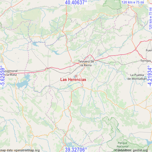
Las Herencias GPS coordinates[2]
39° 52' 7.824" North, 4° 55' 20.856" West
| Map corner | latitude | longitude |
|---|---|---|
| Upper-left | 40.40637°, | -5.62559° |
| Center: | 39.86884°, | -4.92246° |
| Lower-right: | 39.32706°, | -4.21934° |
| Map W x H: | 120×120 km | = 74.6×74.6mi |
| max Lat: | 43.74134° ⇑72.1% North |
| Las Herencias: | 39.86884° |
| min Lat: | ⇓27.9% South 27.64134° |
| min Long | Las Herencias | max Long |
| -18.00367° | -4.92246° | 4.2899° |
| W 28.5%⇐ | ⇒71.5% E |
Elevation
Elevation of Las Herencias is 362 m = 1188 ft, and this is 236 m = 774 ft below average elevation for this country.
| Max E: |
1682 m = 5518 ft | 71.3% |
| Avg. | 598 m = 1962 ft | |
| Las Herencias | 362 m = 1188 ft | |
Min E: |
0 m = 0 ft | 28.7% |
See also: Spain elevation on elevation.city.
Geographical zone
Las Herencias is located in North temperate zone (between Tropic of Cancer and the Arctic Circle). Distance of this Northern Tropic circle is 1827.1 km =1135.3 mi to South.| Distance of | km | miles | from Las Herencias |
|---|---|---|---|
| North Pole | 5574.1 | 3463.6 | to North |
| Arctic Circle | 2968.2 | 1844.4 | to North |
| Tropic Cancer | 1827.1 | 1135.3 | to South |
| Equator | 4433 | 2754.5 | to South |


Nearby cities:
15 places around Las Herencias: (largest is in red/bold)
• Alcañizo
16.1 km =10 mi,  283°
283°
• Alcolea de Tajo
20.3 km =12.6 mi,  251°
251°
• Aldeanueva de Barbarroya
14.9 km =9.3 mi,  215°
215°
• Azután
19.8 km =12.3 mi,  242°
242°
• Belvis de la Jara
12.6 km =7.8 mi,  190°
190°
• Calera y Chozas
5.3 km =3.3 mi,  286°
286°
• Gamonal
10.7 km =6.6 mi,  341°
341°
• La Pueblanueva
21.3 km =13.2 mi,  76°
76°
• Mejorada
16 km =9.9 mi,  11°
11°
• San Bartolomé de las Abiertas
17.9 km =11.1 mi,  104°
104°
• Santa Ana de Pusa
21.7 km =13.5 mi,  123°
123°
• Segurilla
17.9 km =11.1 mi,  16°
16°
• Talavera de la Reina
13.1 km =8.1 mi,  36°
36°
• Torralba de Oropesa
21 km =13 mi, 290°
• Velada
12.9 km =8 mi, 339°
Sources, notices
• [Note1] Compared only with cities in Spain existing in our database
• [Src1] Map data: © OpenStreetMap contributors (CC-BY-SA)
• [Src2] Other city data from geonames.org with taken over terms of usage.
• [Src3] Geographical zone / Annual Mean Temperature by Robert A. Rohde @ Wikipedia
