Mirandilla geodata
Mirandilla (Extremadura) is a seat of a third-order administrative division; located in Spain in Europe/Madrid (GMT+2) time zone. With population of 1,363 people, there are 2584 cities with bigger population in this country. Compared to other cities in Spain, 80.9% of cities are located further ↑North; 89.3% of cities are located further →East and 75.2% of cities have higher elevation than Mirandilla. Note1


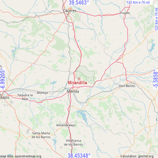
Mirandilla GPS coordinates[2]
39° 0' 7.2" North, 6° 17' 20.148" West
| Map corner | latitude | longitude |
|---|---|---|
| Upper-left | 39.5463°, | -6.99205° |
| Center: | 39.002°, | -6.28893° |
| Lower-right: | 38.45348°, | -5.5858° |
| Map W x H: | 121.5×121.5 km | = 75.5×75.5mi |
| max Lat: | 43.74134° ⇑80.9% North |
| Mirandilla: | 39.002° |
| min Lat: | ⇓19.1% South 27.64134° |
| min Long | Mirandilla | max Long |
| -18.00367° | -6.28893° | 4.2899° |
| W 10.7%⇐ | ⇒89.3% E |
Elevation
Elevation of Mirandilla is 295 m = 968 ft, and this is 303 m = 994 ft below average elevation for this country.
| Max E: |
1682 m = 5518 ft | 75.2% |
| Avg. | 598 m = 1962 ft | |
| Mirandilla | 295 m = 968 ft | |
Min E: |
0 m = 0 ft | 24.8% |
See also: Spain elevation on elevation.city.
Geographical zone
Mirandilla is located in North temperate zone (between Tropic of Cancer and the Arctic Circle). Distance of this Northern Tropic circle is 1730.7 km =1075.4 mi to South.| Distance of | km | miles | from Mirandilla |
|---|---|---|---|
| North Pole | 5670.4 | 3523.4 | to North |
| Arctic Circle | 3064.6 | 1904.3 | to North |
| Tropic Cancer | 1730.7 | 1075.4 | to South |
| Equator | 4336.6 | 2694.6 | to South |


Nearby cities:
15 places around Mirandilla: (largest is in red/bold)
• Alcuéscar
20.6 km =12.8 mi,  14°
14°
• Aljucén
5.9 km =3.7 mi,  322°
322°
• Calamonte
15.2 km =9.4 mi,  214°
214°
• Carmonita
17.5 km =10.9 mi,  345°
345°
• Cordobilla de Lácara
20.6 km =12.8 mi, 321°
• Don Álvaro
17.1 km =10.6 mi,  175°
175°
• Esparragalejo
14.3 km =8.9 mi,  242°
242°
• La Garrovilla
18.7 km =11.6 mi, 240°
• La Nava de Santiago
19.9 km =12.4 mi,  290°
290°
• Mérida
10.7 km =6.6 mi, 206°
• San Pedro de Mérida
10.6 km =6.6 mi,  123°
123°
• Trujillanos
6.2 km =3.9 mi,  153°
153°
• Valdetorres
21.4 km =13.3 mi, 116°
• Valverde de Mérida
11.7 km =7.3 mi, 149°
• Villagonzalo
17.4 km =10.8 mi, 152°
Sources, notices
• [Note1] Compared only with cities in Spain existing in our database
• [Src1] Map data: © OpenStreetMap contributors (CC-BY-SA)
• [Src2] Other city data from geonames.org with taken over terms of usage.
• [Src3] Geographical zone / Annual Mean Temperature by Robert A. Rohde @ Wikipedia
