Aljucén geodata
Aljucén (Extremadura) is a seat of a third-order administrative division; located in Spain in Europe/Madrid (GMT+2) time zone. With population of 246 people, there are 4766 cities with bigger population in this country. Compared to other cities in Spain, 80.6% of cities are located further ↑North; 89.7% of cities are located further →East and 77.1% of cities have higher elevation than Aljucén. Note1


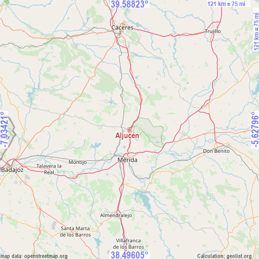
Aljucén GPS coordinates[2]
39° 2' 39.3" North, 6° 19' 51.924" West
| Map corner | latitude | longitude |
|---|---|---|
| Upper-left | 39.58823°, | -7.03421° |
| Center: | 39.04425°, | -6.33109° |
| Lower-right: | 38.49605°, | -5.62796° |
| Map W x H: | 121.4×121.4 km | = 75.4×75.4mi |
| max Lat: | 43.74134° ⇑80.6% North |
| Aljucén: | 39.04425° |
| min Lat: | ⇓19.4% South 27.64134° |
| min Long | Aljucén | max Long |
| -18.00367° | -6.33109° | 4.2899° |
| W 10.3%⇐ | ⇒89.7% E |
Elevation
Elevation of Aljucén is 268 m = 879 ft, and this is 330 m = 1083 ft below average elevation for this country.
| Max E: |
1682 m = 5518 ft | 77.1% |
| Avg. | 598 m = 1962 ft | |
| Aljucén | 268 m = 879 ft | |
Min E: |
0 m = 0 ft | 22.9% |
See also: Spain elevation on elevation.city.
Geographical zone
Aljucén is located in North temperate zone (between Tropic of Cancer and the Arctic Circle). Distance of this Northern Tropic circle is 1735.4 km =1078.3 mi to South.| Distance of | km | miles | from Aljucén |
|---|---|---|---|
| North Pole | 5665.7 | 3520.5 | to North |
| Arctic Circle | 3059.9 | 1901.3 | to North |
| Tropic Cancer | 1735.4 | 1078.3 | to South |
| Equator | 4341.3 | 2697.6 | to South |


Nearby cities:
15 places around Aljucén: (largest is in red/bold)
• Alcuéscar
17.6 km =10.9 mi,  30°
30°
• Arroyomolinos de Montánchez
21.5 km =13.4 mi,  42°
42°
• Calamonte
18 km =11.2 mi,  195°
195°
• Carmonita
12.3 km =7.6 mi,  356°
356°
• Casas de Don Antonio
21.6 km =13.4 mi,  9°
9°
• Cordobilla de Lácara
14.6 km =9.1 mi,  321°
321°
• Don Álvaro
22.3 km =13.9 mi,  167°
167°
• Esparragalejo
14.4 km =8.9 mi,  218°
218°
• La Garrovilla
18.8 km =11.7 mi, 222°
• La Nava de Santiago
15.2 km =9.4 mi,  278°
278°
• Mirandilla
5.9 km =3.7 mi,  142°
142°
• Mérida
14.3 km =8.9 mi,  184°
184°
• San Pedro de Mérida
16.3 km =10.1 mi,  129°
129°
• Trujillanos
12 km =7.5 mi,  148°
148°
• Valverde de Mérida
17.6 km =10.9 mi, 147°
Sources, notices
• [Note1] Compared only with cities in Spain existing in our database
• [Src1] Map data: © OpenStreetMap contributors (CC-BY-SA)
• [Src2] Other city data from geonames.org with taken over terms of usage.
• [Src3] Geographical zone / Annual Mean Temperature by Robert A. Rohde @ Wikipedia
