Utrera geodata
Utrera (Andalusia) is a seat of a third-order administrative division; located in Spain in Europe/Madrid (GMT+2) time zone. With population of 50,665 people, there are 183 cities with bigger population in this country. Compared to other cities in Spain, 94.1% of cities are located further ↑North; 83% of cities are located further →East and 91% of cities have higher elevation than Utrera. Note1


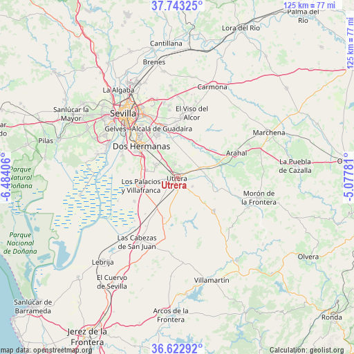
Utrera GPS coordinates[2]
37° 11' 6.576" North, 5° 46' 51.348" West
| Map corner | latitude | longitude |
|---|---|---|
| Upper-left | 37.74325°, | -6.48406° |
| Center: | 37.18516°, | -5.78093° |
| Lower-right: | 36.62292°, | -5.07781° |
| Map W x H: | 124.6×124.6 km | = 77.4×77.4mi |
| max Lat: | 43.74134° ⇑94.1% North |
| Utrera: | 37.18516° |
| min Lat: | ⇓5.9% South 27.64134° |
| min Long | Utrera | max Long |
| -18.00367° | -5.78093° | 4.2899° |
| W 17%⇐ | ⇒83% E |
Elevation
Elevation of Utrera is 52 m = 171 ft, and this is 546 m = 1791 ft below average elevation for this country.
| Max E: |
1682 m = 5518 ft | 91% |
| Avg. | 598 m = 1962 ft | |
| Utrera | 52 m = 171 ft | |
Min E: |
0 m = 0 ft | 9% |
See also: Utrera elevation on elevation.city.
Geographical zone
Utrera is located in North temperate zone (between Tropic of Cancer and the Arctic Circle). Distance of this Northern Tropic circle is 1528.7 km =949.9 mi to South.| Distance of | km | miles | from Utrera |
|---|---|---|---|
| North Pole | 5872.5 | 3649 | to North |
| Arctic Circle | 3266.6 | 2029.8 | to North |
| Tropic Cancer | 1528.7 | 949.9 | to South |
| Equator | 4134.6 | 2569.1 | to South |


Nearby cities:
15 places around Utrera: (largest is in red/bold)
• Alcalá de Guadaira
17.8 km =11.1 mi,  343°
343°
• Coria del Río
26.7 km =16.6 mi,  295°
295°
• Dos Hermanas
16.5 km =10.3 mi,  311°
311°
• El Arahal
22.6 km =14 mi,  67°
67°
• El Coronil
17.5 km =10.9 mi,  132°
132°
• El Viso del Alcor
23.5 km =14.6 mi,  13°
13°
• Gelves
27.3 km =17 mi, 307°
• La Puebla del Río
26.6 km =16.5 mi,  290°
290°
• Las Cabezas de San Juan
26.4 km =16.4 mi,  212°
212°
• Los Molares
6.4 km =4 mi,  119°
119°
• Los Palacios y Villafranca
13 km =8.1 mi,  258°
258°
• Mairena del Alcor
21.1 km =13.1 mi, 7°
• Montellano
28.1 km =17.5 mi,  138°
138°
• Paradas
27.7 km =17.2 mi, 65°
• Sevilla
27.8 km =17.3 mi,  322°
322°
Sources, notices
• [Note1] Compared only with cities in Spain existing in our database
• [Src1] Map data: © OpenStreetMap contributors (CC-BY-SA)
• [Src2] Other city data from geonames.org with taken over terms of usage.
• [Src3] Geographical zone / Annual Mean Temperature by Robert A. Rohde @ Wikipedia
