Los Molares geodata
Los Molares (Andalusia) is a populated place; located in Spain in Europe/Madrid (GMT+2) time zone. With population of 2,838 people, there are 1775 cities with bigger population in this country. Compared to other cities in Spain, 94.5% of cities are located further ↑North; 82% of cities are located further →East and 88.8% of cities have higher elevation than Los Molares. Note1


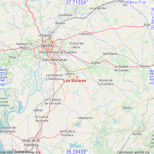
Los Molares GPS coordinates[2]
37° 9' 25.344" North, 5° 43' 4.872" West
| Map corner | latitude | longitude |
|---|---|---|
| Upper-left | 37.71534°, | -6.42115° |
| Center: | 37.15704°, | -5.71802° |
| Lower-right: | 36.59459°, | -5.0149° |
| Map W x H: | 124.6×124.6 km | = 77.4×77.4mi |
| max Lat: | 43.74134° ⇑94.5% North |
| Los Molares: | 37.15704° |
| min Lat: | ⇓5.5% South 27.64134° |
| min Long | Los Molares | max Long |
| -18.00367° | -5.71802° | 4.2899° |
| W 18%⇐ | ⇒82% E |
Elevation
Elevation of Los Molares is 84 m = 276 ft, and this is 514 m = 1686 ft below average elevation for this country.
| Max E: |
1682 m = 5518 ft | 88.8% |
| Avg. | 598 m = 1962 ft | |
| Los Molares | 84 m = 276 ft | |
Min E: |
0 m = 0 ft | 11.2% |
See also: Spain elevation on elevation.city.
Geographical zone
Los Molares is located in North temperate zone (between Tropic of Cancer and the Arctic Circle). Distance of this Northern Tropic circle is 1525.6 km =948 mi to South.| Distance of | km | miles | from Los Molares |
|---|---|---|---|
| North Pole | 5875.6 | 3650.9 | to North |
| Arctic Circle | 3269.7 | 2031.7 | to North |
| Tropic Cancer | 1525.6 | 948 | to South |
| Equator | 4131.5 | 2567.2 | to South |


Nearby cities:
15 places around Los Molares: (largest is in red/bold)
• Alcalá de Guadaira
22.8 km =14.2 mi,  331°
331°
• Coripe
32 km =19.9 mi,  129°
129°
• Dos Hermanas
22.8 km =14.2 mi,  307°
307°
• El Arahal
19.3 km =12 mi,  52°
52°
• El Coronil
11.4 km =7.1 mi,  139°
139°
• El Viso del Alcor
26 km =16.2 mi,  359°
359°
• Espera
32.4 km =20.1 mi,  193°
193°
• Las Cabezas de San Juan
27.5 km =17.1 mi,  225°
225°
• Los Palacios y Villafranca
18.3 km =11.4 mi,  271°
271°
• Mairena del Alcor
24.2 km =15 mi,  353°
353°
• Montellano
22.2 km =13.8 mi, 144°
• Morón de la Frontera
23.7 km =14.7 mi,  99°
99°
• Paradas
24.6 km =15.3 mi, 52°
• Puerto Serrano
30.4 km =18.9 mi,  149°
149°
• Utrera
6.4 km =4 mi,  299°
299°
Sources, notices
• [Note1] Compared only with cities in Spain existing in our database
• [Src1] Map data: © OpenStreetMap contributors (CC-BY-SA)
• [Src2] Other city data from geonames.org with taken over terms of usage.
• [Src3] Geographical zone / Annual Mean Temperature by Robert A. Rohde @ Wikipedia
