Archidona geodata
Archidona (Andalusia) is a seat of a third-order administrative division; located in Spain in Europe/Madrid (GMT+2) time zone. With population of 8,506 people, there are 912 cities with bigger population in this country. Compared to other cities in Spain, 94.8% of cities are located further ↑North; 64.8% of cities are located further →East and 58.1% of cities have lower elevation than Archidona. Note1


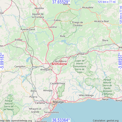
Archidona GPS coordinates[2]
37° 5' 47.544" North, 4° 23' 19.284" West
| Map corner | latitude | longitude |
|---|---|---|
| Upper-left | 37.65529°, | -5.09182° |
| Center: | 37.09654°, | -4.38869° |
| Lower-right: | 36.53364°, | -3.68557° |
| Map W x H: | 124.7×124.7 km | = 77.5×77.5mi |
| max Lat: | 43.74134° ⇑94.8% North |
| Archidona: | 37.09654° |
| min Lat: | ⇓5.2% South 27.64134° |
| min Long | Archidona | max Long |
| -18.00367° | -4.38869° | 4.2899° |
| W 35.2%⇐ | ⇒64.8% E |
Elevation
Elevation of Archidona is 730 m = 2395 ft, and this is 132 m = 433 ft above average elevation for this country.
| Max E: |
1682 m = 5518 ft | 41.9% |
| Archidona | 730 m 2395 ft | |
| Avg. | 598 m = 1962 ft | |
Min E: |
0 m = 0 ft | 58.1% |
See also: Spain elevation on elevation.city.
Geographical zone
Archidona is located in North temperate zone (between Tropic of Cancer and the Arctic Circle). Distance of this Northern Tropic circle is 1518.8 km =943.7 mi to South.| Distance of | km | miles | from Archidona |
|---|---|---|---|
| North Pole | 5882.3 | 3655.1 | to North |
| Arctic Circle | 3276.4 | 2035.9 | to North |
| Tropic Cancer | 1518.8 | 943.7 | to South |
| Equator | 4124.7 | 2563 | to South |


Nearby cities:
15 places around Archidona: (largest is in red/bold)
• Alfarnate
16.2 km =10.1 mi,  134°
134°
• Alfarnatejo
16 km =9.9 mi, 134°
• Antequera
17.5 km =10.9 mi,  240°
240°
• Casabermeja
23 km =14.3 mi,  189°
189°
• Colmenar
21.8 km =13.5 mi,  167°
167°
• Cuevas Bajas
17.7 km =11 mi,  330°
330°
• Cuevas de San Marcos
19.1 km =11.9 mi,  353°
353°
• Encinas Reales
21.6 km =13.4 mi,  335°
335°
• Iznájar
19.3 km =12 mi,  21°
21°
• Loja
22.5 km =14 mi,  69°
69°
• Ríogordo
21.7 km =13.5 mi,  156°
156°
• Villanueva de Algaidas
11.1 km =6.9 mi, 330°
• Villanueva de Tapia
10.7 km =6.6 mi,  26°
26°
• Villanueva del Rosario
11.3 km =7 mi, 169°
• Villanueva del Trabuco
8.8 km =5.5 mi,  149°
149°
Sources, notices
• [Note1] Compared only with cities in Spain existing in our database
• [Src1] Map data: © OpenStreetMap contributors (CC-BY-SA)
• [Src2] Other city data from geonames.org with taken over terms of usage.
• [Src3] Geographical zone / Annual Mean Temperature by Robert A. Rohde @ Wikipedia
