Iznájar geodata
Iznájar (Andalusia) is a seat of a third-order administrative division; located in Spain in Europe/Madrid (GMT+2) time zone. With population of 4,913 people, there are 1325 cities with bigger population in this country. Compared to other cities in Spain, 93.4% of cities are located further ↑North; 63.9% of cities are located further →East and 60.2% of cities have higher elevation than Iznájar. Note1


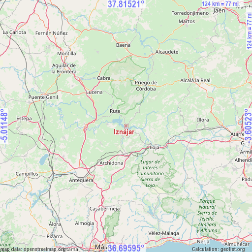
Iznájar GPS coordinates[2]
37° 15' 27.576" North, 4° 18' 30.096" West
| Map corner | latitude | longitude |
|---|---|---|
| Upper-left | 37.81521°, | -5.01148° |
| Center: | 37.25766°, | -4.30836° |
| Lower-right: | 36.69595°, | -3.60523° |
| Map W x H: | 124.5×124.4 km | = 77.4×77.3mi |
| max Lat: | 43.74134° ⇑93.4% North |
| Iznájar: | 37.25766° |
| min Lat: | ⇓6.6% South 27.64134° |
| min Long | Iznájar | max Long |
| -18.00367° | -4.30836° | 4.2899° |
| W 36.1%⇐ | ⇒63.9% E |
Elevation
Elevation of Iznájar is 525 m = 1722 ft, and this is 73 m = 240 ft below average elevation for this country.
| Max E: |
1682 m = 5518 ft | 60.2% |
| Avg. | 598 m = 1962 ft | |
| Iznájar | 525 m = 1722 ft | |
Min E: |
0 m = 0 ft | 39.8% |
See also: Spain elevation on elevation.city.
Geographical zone
Iznájar is located in North temperate zone (between Tropic of Cancer and the Arctic Circle). Distance of this Northern Tropic circle is 1536.7 km =954.9 mi to South.| Distance of | km | miles | from Iznájar |
|---|---|---|---|
| North Pole | 5864.4 | 3644 | to North |
| Arctic Circle | 3258.5 | 2024.7 | to North |
| Tropic Cancer | 1536.7 | 954.9 | to South |
| Equator | 4142.7 | 2574.2 | to South |


Nearby cities:
15 places around Iznájar: (largest is in red/bold)
• Algarinejo
15.2 km =9.4 mi,  60°
60°
• Archidona
19.3 km =12 mi,  201°
201°
• Benamejí
20.6 km =12.8 mi,  273°
273°
• Carcabuey
21 km =13 mi,  8°
8°
• Cuevas Bajas
16 km =9.9 mi,  261°
261°
• Cuevas de San Marcos
9.4 km =5.8 mi,  276°
276°
• Encinas Reales
16 km =9.9 mi, 276°
• Huétor-Tájar
24.1 km =15 mi,  105°
105°
• Loja
17.1 km =10.6 mi,  125°
125°
• Lucena
23 km =14.3 mi,  317°
317°
• Priego de Córdoba
22.4 km =13.9 mi,  26°
26°
• Rute
9.3 km =5.8 mi,  325°
325°
• Villanueva de Algaidas
15 km =9.3 mi,  236°
236°
• Villanueva de Tapia
8.6 km =5.3 mi, 195°
• Zagra
12.3 km =7.6 mi,  91°
91°
Sources, notices
• [Note1] Compared only with cities in Spain existing in our database
• [Src1] Map data: © OpenStreetMap contributors (CC-BY-SA)
• [Src2] Other city data from geonames.org with taken over terms of usage.
• [Src3] Geographical zone / Annual Mean Temperature by Robert A. Rohde @ Wikipedia
