Castelló de la Plana geodata
Castelló de la Plana (Valencia) is a seat of a second-order administrative division; located in Spain in Europe/Madrid (GMT+2) time zone. With population of 180,005 people, there are 43 cities with bigger population in this country. Compared to other cities in Spain, 70.4% of cities are located further ↑North; 86.7% of cities are located further ←West and 93.2% of cities have higher elevation than Castelló de la Plana. Note1
Administrative division(s):
- Level 1: Valencia
- Level 2: Província de Castelló
- Level 3: Castellón de la Plana/Castelló de la Plana


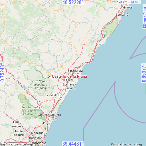
Castelló de la Plana GPS coordinates[2]
39° 59' 8.412" North, 0° 2' 57.66" West
| Map corner | latitude | longitude |
|---|---|---|
| Upper-left | 40.52228°, | -0.75248° |
| Center: | 39.98567°, | -0.04935° |
| Lower-right: | 39.44481°, | 0.65377° |
| Map W x H: | 119.8×119.8 km | = 74.4×74.4mi |
| max Lat: | 43.74134° ⇑70.4% North |
| Castelló de la Plana: | 39.98567° |
| min Lat: | ⇓29.6% South 27.64134° |
| min Long | Castelló de la | max Long |
| -18.00367° | -0.04935° | 4.2899° |
| W 86.7%⇐ | ⇒13.3% E |
Elevation
Elevation of Castelló de la Plana is 37 m = 121 ft, and this is 561 m = 1841 ft below average elevation for this country.
| Max E: |
1682 m = 5518 ft | 93.2% |
| Avg. | 598 m = 1962 ft | |
| Castelló de la Plana | 37 m = 121 ft | |
Min E: |
0 m = 0 ft | 6.8% |
See also: Castelló de la Plana elevation on elevation.city.
Geographical zone
Castelló de la Plana is located in North temperate zone (between Tropic of Cancer and the Arctic Circle). Distance of this Northern Tropic circle is 1840.1 km =1143.4 mi to South.| Distance of | km | miles | from Castelló de la Plana |
|---|---|---|---|
| North Pole | 5561.1 | 3455.5 | to North |
| Arctic Circle | 2955.2 | 1836.3 | to North |
| Tropic Cancer | 1840.1 | 1143.4 | to South |
| Equator | 4446 | 2762.6 | to South |


Nearby cities:
15 places around Castelló de la Plana: (largest is in red/bold)
• Almassora
4.4 km =2.7 mi,  195°
195°
• Alquerías del Niño Perdido
12.2 km =7.6 mi,  214°
214°
• Benicàssim
12.2 km =7.6 mi,  54°
54°
• Betxí
14.1 km =8.8 mi,  245°
245°
• Borriol
6.6 km =4.1 mi,  344°
344°
• Burriana
11.2 km =7 mi, 195°
• Costur
18.3 km =11.4 mi,  324°
324°
• El Grao
5.5 km =3.4 mi,  104°
104°
• Nules
17.3 km =10.7 mi, 211°
• Onda
18.1 km =11.2 mi,  262°
262°
• Puebla Tornesa
13.6 km =8.5 mi,  17°
17°
• San Juan de Moró
11.1 km =6.9 mi, 317°
• Vila-real
6.9 km =4.3 mi,  219°
219°
• Villafamés
14.6 km =9.1 mi,  359°
359°
• l'Alcora
15.7 km =9.8 mi,  305°
305°
In other languages:
- In Spanish: Castellón de la Plana, Castelló de la Plana
- In France: Castellón de la Plana
- In German: Castellón de la Plana
- In Italian: Castellón de la Plana
- In Russian: Кастельон-де-ла-Плана
Sources, notices
• [Note1] Compared only with cities in Spain existing in our database
• [Src1] Map data: © OpenStreetMap contributors (CC-BY-SA)
• [Src2] Other city data from geonames.org with taken over terms of usage.
• [Src3] Geographical zone / Annual Mean Temperature by Robert A. Rohde @ Wikipedia
