San Juan de Moró geodata
San Juan de Moró (Valencia) is a populated place; located in Spain in Europe/Madrid (GMT+2) time zone. With population of 1,947 people, there are 2205 cities with bigger population in this country. Compared to other cities in Spain, 69.4% of cities are located further ↑North; 86.1% of cities are located further ←West and 81.7% of cities have higher elevation than San Juan de Moró. Note1
Administrative division(s):
- Level 1: Valencia
- Level 2: Província de Castelló
- Level 3: Castellón de la Plana/Castelló de la Plana


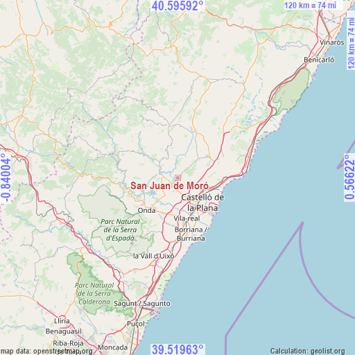
San Juan de Moró GPS coordinates[2]
40° 3' 35.64" North, 0° 8' 12.876" West
| Map corner | latitude | longitude |
|---|---|---|
| Upper-left | 40.59592°, | -0.84004° |
| Center: | 40.0599°, | -0.13691° |
| Lower-right: | 39.51963°, | 0.56622° |
| Map W x H: | 119.7×119.7 km | = 74.4×74.4mi |
| max Lat: | 43.74134° ⇑69.4% North |
| San Juan de Moró: | 40.0599° |
| min Lat: | ⇓30.6% South 27.64134° |
| min Long | San Juan de Mor | max Long |
| -18.00367° | -0.13691° | 4.2899° |
| W 86.1%⇐ | ⇒13.9% E |
Elevation
Elevation of San Juan de Moró is 192 m = 630 ft, and this is 406 m = 1332 ft below average elevation for this country.
| Max E: |
1682 m = 5518 ft | 81.7% |
| Avg. | 598 m = 1962 ft | |
| San Juan de Moró | 192 m = 630 ft | |
Min E: |
0 m = 0 ft | 18.3% |
See also: Spain elevation on elevation.city.
Geographical zone
San Juan de Moró is located in North temperate zone (between Tropic of Cancer and the Arctic Circle). Distance of this Northern Tropic circle is 1848.3 km =1148.5 mi to South.| Distance of | km | miles | from San Juan de Moró |
|---|---|---|---|
| North Pole | 5552.8 | 3450.3 | to North |
| Arctic Circle | 2946.9 | 1831.1 | to North |
| Tropic Cancer | 1848.3 | 1148.5 | to South |
| Equator | 4454.2 | 2767.7 | to South |


Nearby cities:
15 places around San Juan de Moró: (largest is in red/bold)
• Almassora
14 km =8.7 mi,  153°
153°
• Betxí
15.1 km =9.4 mi,  200°
200°
• Borriol
6 km =3.7 mi,  108°
108°
• Castelló de la Plana
11.1 km =6.9 mi,  137°
137°
• Costur
7.4 km =4.6 mi,  334°
334°
• El Grao
16 km =9.9 mi,  126°
126°
• Figueroles
10.3 km =6.4 mi,  307°
307°
• Lucena del Cid
14.9 km =9.3 mi,  303°
303°
• Onda
14.9 km =9.3 mi,  224°
224°
• Puebla Tornesa
12.5 km =7.8 mi,  67°
67°
• Ribesalbes
12 km =7.5 mi,  246°
246°
• Useras
11.1 km =6.9 mi,  347°
347°
• Vila-real
13.9 km =8.6 mi,  167°
167°
• Villafamés
9.7 km =6 mi,  49°
49°
• l'Alcora
5.4 km =3.4 mi,  277°
277°
Sources, notices
• [Note1] Compared only with cities in Spain existing in our database
• [Src1] Map data: © OpenStreetMap contributors (CC-BY-SA)
• [Src2] Other city data from geonames.org with taken over terms of usage.
• [Src3] Geographical zone / Annual Mean Temperature by Robert A. Rohde @ Wikipedia
