Borriol geodata
Borriol (Valencia) is a seat of a third-order administrative division; located in Spain in Europe/Madrid (GMT+2) time zone. With population of 4,321 people, there are 1413 cities with bigger population in this country. Compared to other cities in Spain, 69.7% of cities are located further ↑North; 86.5% of cities are located further ←West and 81.2% of cities have higher elevation than Borriol. Note1


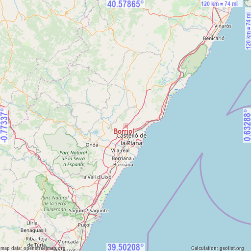
Borriol GPS coordinates[2]
40° 2' 32.964" North, 0° 4' 12.9" West
| Map corner | latitude | longitude |
|---|---|---|
| Upper-left | 40.57865°, | -0.77337° |
| Center: | 40.04249°, | -0.07025° |
| Lower-right: | 39.50208°, | 0.63288° |
| Map W x H: | 119.7×119.7 km | = 74.4×74.4mi |
| max Lat: | 43.74134° ⇑69.7% North |
| Borriol: | 40.04249° |
| min Lat: | ⇓30.3% South 27.64134° |
| min Long | Borriol | max Long |
| -18.00367° | -0.07025° | 4.2899° |
| W 86.5%⇐ | ⇒13.5% E |
Elevation
Elevation of Borriol is 199 m = 653 ft, and this is 399 m = 1309 ft below average elevation for this country.
| Max E: |
1682 m = 5518 ft | 81.2% |
| Avg. | 598 m = 1962 ft | |
| Borriol | 199 m = 653 ft | |
Min E: |
0 m = 0 ft | 18.8% |
See also: Spain elevation on elevation.city.
Geographical zone
Borriol is located in North temperate zone (between Tropic of Cancer and the Arctic Circle). Distance of this Northern Tropic circle is 1846.4 km =1147.3 mi to South.| Distance of | km | miles | from Borriol |
|---|---|---|---|
| North Pole | 5554.8 | 3451.6 | to North |
| Arctic Circle | 2948.9 | 1832.4 | to North |
| Tropic Cancer | 1846.4 | 1147.3 | to South |
| Equator | 4452.3 | 2766.5 | to South |


Nearby cities:
15 places around Borriol: (largest is in red/bold)
• Almassora
10.6 km =6.6 mi,  176°
176°
• Benicàssim
11.7 km =7.3 mi,  85°
85°
• Betxí
16.4 km =10.2 mi,  222°
222°
• Cabanes
15.9 km =9.9 mi,  37°
37°
• Castelló de la Plana
6.6 km =4.1 mi,  164°
164°
• Costur
12.3 km =7.6 mi,  314°
314°
• El Grao
10.4 km =6.5 mi,  137°
137°
• Figueroles
16.1 km =10 mi,  300°
300°
• Puebla Tornesa
8.9 km =5.5 mi, 41°
• Ribesalbes
17 km =10.6 mi,  260°
260°
• San Juan de Moró
6 km =3.7 mi,  288°
288°
• Useras
15.1 km =9.4 mi,  327°
327°
• Vila-real
11.9 km =7.4 mi,  192°
192°
• Villafamés
8.4 km =5.2 mi,  11°
11°
• l'Alcora
11.4 km =7.1 mi,  283°
283°
Sources, notices
• [Note1] Compared only with cities in Spain existing in our database
• [Src1] Map data: © OpenStreetMap contributors (CC-BY-SA)
• [Src2] Other city data from geonames.org with taken over terms of usage.
• [Src3] Geographical zone / Annual Mean Temperature by Robert A. Rohde @ Wikipedia
