Pedrera geodata
Pedrera (Andalusia) is a seat of a third-order administrative division; located in Spain in Europe/Madrid (GMT+2) time zone. With population of 5,049 people, there are 1294 cities with bigger population in this country. Compared to other cities in Spain, 93.7% of cities are located further ↑North; 71% of cities are located further →East and 65.1% of cities have higher elevation than Pedrera. Note1


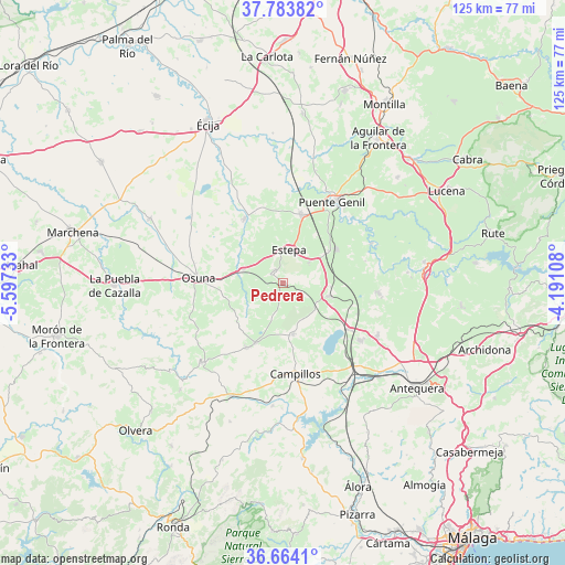
Pedrera GPS coordinates[2]
37° 13' 33.744" North, 4° 53' 39.12" West
| Map corner | latitude | longitude |
|---|---|---|
| Upper-left | 37.78382°, | -5.59733° |
| Center: | 37.22604°, | -4.8942° |
| Lower-right: | 36.6641°, | -4.19108° |
| Map W x H: | 124.5×124.5 km | = 77.4×77.4mi |
| max Lat: | 43.74134° ⇑93.7% North |
| Pedrera: | 37.22604° |
| min Lat: | ⇓6.3% South 27.64134° |
| min Long | Pedrera | max Long |
| -18.00367° | -4.8942° | 4.2899° |
| W 29%⇐ | ⇒71% E |
Elevation
Elevation of Pedrera is 459 m = 1506 ft, and this is 139 m = 456 ft below average elevation for this country.
| Max E: |
1682 m = 5518 ft | 65.1% |
| Avg. | 598 m = 1962 ft | |
| Pedrera | 459 m = 1506 ft | |
Min E: |
0 m = 0 ft | 34.9% |
See also: Spain elevation on elevation.city.
Geographical zone
Pedrera is located in North temperate zone (between Tropic of Cancer and the Arctic Circle). Distance of this Northern Tropic circle is 1533.2 km =952.7 mi to South.| Distance of | km | miles | from Pedrera |
|---|---|---|---|
| North Pole | 5867.9 | 3646.1 | to North |
| Arctic Circle | 3262 | 2026.9 | to North |
| Tropic Cancer | 1533.2 | 952.7 | to South |
| Equator | 4139.1 | 2571.9 | to South |


Nearby cities:
15 places around Pedrera: (largest is in red/bold)
• Aguadulce
9.2 km =5.7 mi,  288°
288°
• Campillos
20 km =12.4 mi,  172°
172°
• Casariche
14.1 km =8.8 mi,  57°
57°
• El Rubio
16.7 km =10.4 mi,  329°
329°
• Estepa
7.5 km =4.7 mi,  10°
10°
• Fuente de Piedra
17.7 km =11 mi,  124°
124°
• Gilena
3.3 km =2.1 mi, 327°
• Herrera
15.8 km =9.8 mi, 14°
• La Roda de Andalucía
10.6 km =6.6 mi,  103°
103°
• Lora de Estepa
7.6 km =4.7 mi,  50°
50°
• Los Corrales
16.2 km =10.1 mi,  209°
209°
• Marinaleda
17.1 km =10.6 mi,  340°
340°
• Martín de la Jara
14.4 km =8.9 mi, 205°
• Osuna
18.5 km =11.5 mi,  273°
273°
• Sierra de Yeguas
11.6 km =7.2 mi, 168°
Sources, notices
• [Note1] Compared only with cities in Spain existing in our database
• [Src1] Map data: © OpenStreetMap contributors (CC-BY-SA)
• [Src2] Other city data from geonames.org with taken over terms of usage.
• [Src3] Geographical zone / Annual Mean Temperature by Robert A. Rohde @ Wikipedia
