Estepa geodata
Estepa (Andalusia) is a seat of a third-order administrative division; located in Spain in Europe/Madrid (GMT+2) time zone. With population of 12,632 people, there are 724 cities with bigger population in this country. Compared to other cities in Spain, 93% of cities are located further ↑North; 70.9% of cities are located further →East and 60.3% of cities have higher elevation than Estepa. Note1


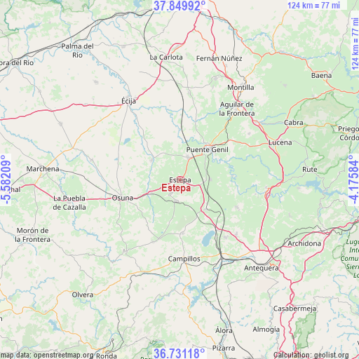
Estepa GPS coordinates[2]
37° 17' 33.468" North, 4° 52' 44.256" West
| Map corner | latitude | longitude |
|---|---|---|
| Upper-left | 37.84992°, | -5.58209° |
| Center: | 37.29263°, | -4.87896° |
| Lower-right: | 36.73118°, | -4.17584° |
| Map W x H: | 124.4×124.4 km | = 77.3×77.3mi |
| max Lat: | 43.74134° ⇑93% North |
| Estepa: | 37.29263° |
| min Lat: | ⇓7% South 27.64134° |
| min Long | Estepa | max Long |
| -18.00367° | -4.87896° | 4.2899° |
| W 29.1%⇐ | ⇒70.9% E |
Elevation
Elevation of Estepa is 523 m = 1716 ft, and this is 75 m = 246 ft below average elevation for this country.
| Max E: |
1682 m = 5518 ft | 60.3% |
| Avg. | 598 m = 1962 ft | |
| Estepa | 523 m = 1716 ft | |
Min E: |
0 m = 0 ft | 39.7% |
See also: Spain elevation on elevation.city.
Geographical zone
Estepa is located in North temperate zone (between Tropic of Cancer and the Arctic Circle). Distance of this Northern Tropic circle is 1540.6 km =957.3 mi to South.| Distance of | km | miles | from Estepa |
|---|---|---|---|
| North Pole | 5860.5 | 3641.5 | to North |
| Arctic Circle | 3254.6 | 2022.3 | to North |
| Tropic Cancer | 1540.6 | 957.3 | to South |
| Equator | 4146.6 | 2576.6 | to South |


Nearby cities:
15 places around Estepa: (largest is in red/bold)
• Aguadulce
11 km =6.8 mi,  246°
246°
• Alameda
21.6 km =13.4 mi,  115°
115°
• Badolatosa
18.3 km =11.4 mi,  84°
84°
• Casariche
10.5 km =6.5 mi,  89°
89°
• El Rubio
12 km =7.5 mi,  305°
305°
• Gilena
5.5 km =3.4 mi,  214°
214°
• Herrera
8.3 km =5.2 mi,  18°
18°
• La Roda de Andalucía
13.3 km =8.3 mi,  137°
137°
• Lora de Estepa
5.2 km =3.2 mi, 119°
• Marinaleda
11.3 km =7 mi,  320°
320°
• Martín de la Jara
21.8 km =13.5 mi,  200°
200°
• Osuna
20.8 km =12.9 mi, 252°
• Pedrera
7.5 km =4.7 mi,  190°
190°
• Puente-Genil
14.6 km =9.1 mi,  42°
42°
• Sierra de Yeguas
18.8 km =11.7 mi,  176°
176°
Sources, notices
• [Note1] Compared only with cities in Spain existing in our database
• [Src1] Map data: © OpenStreetMap contributors (CC-BY-SA)
• [Src2] Other city data from geonames.org with taken over terms of usage.
• [Src3] Geographical zone / Annual Mean Temperature by Robert A. Rohde @ Wikipedia
