Marchena geodata
Marchena (Andalusia) is a seat of a third-order administrative division; located in Spain in Europe/Madrid (GMT+2) time zone. With population of 19,768 people, there are 482 cities with bigger population in this country. Compared to other cities in Spain, 92.7% of cities are located further ↑North; 77.6% of cities are located further →East and 85.5% of cities have higher elevation than Marchena. Note1


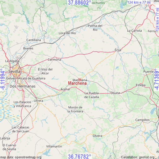
Marchena GPS coordinates[2]
37° 19' 44.4" North, 5° 25' 0.516" West
| Map corner | latitude | longitude |
|---|---|---|
| Upper-left | 37.88602°, | -6.11994° |
| Center: | 37.329°, | -5.41681° |
| Lower-right: | 36.76782°, | -4.71369° |
| Map W x H: | 124.3×124.3 km | = 77.2×77.2mi |
| max Lat: | 43.74134° ⇑92.7% North |
| Marchena: | 37.329° |
| min Lat: | ⇓7.3% South 27.64134° |
| min Long | Marchena | max Long |
| -18.00367° | -5.41681° | 4.2899° |
| W 22.4%⇐ | ⇒77.6% E |
Elevation
Elevation of Marchena is 131 m = 430 ft, and this is 467 m = 1532 ft below average elevation for this country.
| Max E: |
1682 m = 5518 ft | 85.5% |
| Avg. | 598 m = 1962 ft | |
| Marchena | 131 m = 430 ft | |
Min E: |
0 m = 0 ft | 14.5% |
See also: Spain elevation on elevation.city.
Geographical zone
Marchena is located in North temperate zone (between Tropic of Cancer and the Arctic Circle). Distance of this Northern Tropic circle is 1544.7 km =959.8 mi to South.| Distance of | km | miles | from Marchena |
|---|---|---|---|
| North Pole | 5856.5 | 3639.1 | to North |
| Arctic Circle | 3250.6 | 2019.8 | to North |
| Tropic Cancer | 1544.7 | 959.8 | to South |
| Equator | 4150.6 | 2579.1 | to South |


Nearby cities:
15 places around Marchena: (largest is in red/bold)
• Carmona
25.7 km =16 mi,  307°
307°
• Cañada Rosal
35.1 km =21.8 mi,  31°
31°
• El Arahal
13.5 km =8.4 mi,  237°
237°
• El Coronil
33.8 km =21 mi,  214°
214°
• El Viso del Alcor
27.7 km =17.2 mi,  284°
284°
• Fuentes de Andalucía
16.3 km =10.1 mi,  22°
22°
• La Campana
26.7 km =16.6 mi,  358°
358°
• La Lantejuela
17.2 km =10.7 mi,  80°
80°
• La Luisiana
26.5 km =16.5 mi, 34°
• La Puebla de Cazalla
15.1 km =9.4 mi,  142°
142°
• Los Molares
32.8 km =20.4 mi,  234°
234°
• Mairena del Alcor
29.8 km =18.5 mi, 279°
• Morón de la Frontera
23.4 km =14.5 mi,  188°
188°
• Osuna
29.6 km =18.4 mi,  110°
110°
• Paradas
8.3 km =5.2 mi, 238°
Sources, notices
• [Note1] Compared only with cities in Spain existing in our database
• [Src1] Map data: © OpenStreetMap contributors (CC-BY-SA)
• [Src2] Other city data from geonames.org with taken over terms of usage.
• [Src3] Geographical zone / Annual Mean Temperature by Robert A. Rohde @ Wikipedia
