Alicante geodata
Alicante (Valencia) is a seat of a second-order administrative division; located in Spain in Europe/Madrid (GMT+2) time zone. With population of 334,757 people, there are 10 cities with bigger population in this country. Compared to other cities in Spain, 86.5% of cities are located further ↑North; 81.9% of cities are located further ←West and 96.4% of cities have higher elevation than Alicante. Note1


Alicante GPS coordinates[2]
38° 20' 42.612" North, 0° 28' 53.364" West
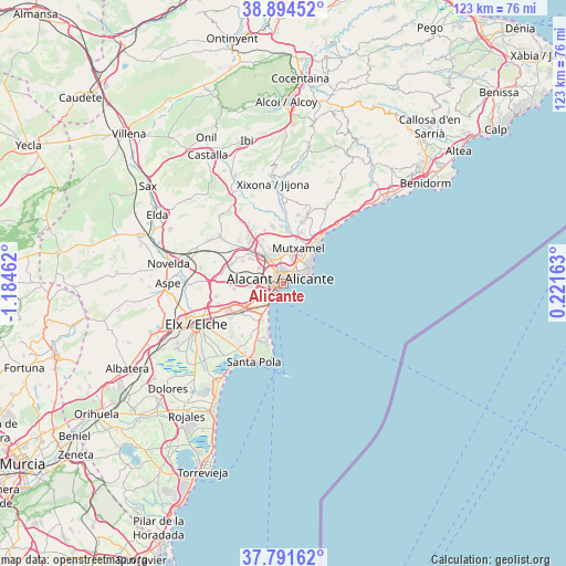
| Map corner | latitude | longitude |
|---|---|---|
| Upper-left | 38.89452°, | -1.18462° |
| Center: | 38.34517°, | -0.48149° |
| Lower-right: | 37.79162°, | 0.22163° |
| Map W x H: | 122.6×122.6 km | = 76.2×76.2mi |
| max Lat: | 43.74134° ⇑86.5% North |
| Alicante: | 38.34517° |
| min Lat: | ⇓13.5% South 27.64134° |
| min Long | Alicante | max Long |
| -18.00367° | -0.48149° | 4.2899° |
| W 81.9%⇐ | ⇒18.1% E |
Elevation
Elevation of Alicante is 18 m = 59 ft, and this is 580 m = 1903 ft below average elevation for this country.
| Max E: |
1682 m = 5518 ft | 96.4% |
| Avg. | 598 m = 1962 ft | |
| Alicante | 18 m = 59 ft | |
Min E: |
0 m = 0 ft | 3.6% |
See also: Alicante elevation on elevation.city.
Geographical zone
Alicante is located in North temperate zone (between Tropic of Cancer and the Arctic Circle). Distance of this Northern Tropic circle is 1657.7 km =1030 mi to South.| Distance of | km | miles | from Alicante |
|---|---|---|---|
| North Pole | 5743.5 | 3568.8 | to North |
| Arctic Circle | 3137.6 | 1949.6 | to North |
| Tropic Cancer | 1657.7 | 1030 | to South |
| Equator | 4263.6 | 2649.3 | to South |


Nearby cities:
15 places around Alicante: (largest is in red/bold)
• Agost
17.3 km =10.7 mi,  307°
307°
• Aigües
20.7 km =12.9 mi,  33°
33°
• Aspe
24.9 km =15.5 mi,  269°
269°
• Busot
16.2 km =10.1 mi,  19°
19°
• El Campello
11.8 km =7.3 mi,  38°
38°
• Elche
21.3 km =13.2 mi,  244°
244°
• Jijona
21.8 km =13.5 mi,  355°
355°
• Monforte del Cid
21.9 km =13.6 mi,  280°
280°
• Mutxamel
8.5 km =5.3 mi, 21°
• Novelda
25.3 km =15.7 mi, 280°
• San Juan de Alicante
7.4 km =4.6 mi, 32°
• San Vicent del Raspeig
6.9 km =4.3 mi,  326°
326°
• Santa Pola
18.6 km =11.6 mi,  203°
203°
• Tibi
22.3 km =13.9 mi,  337°
337°
• Villajoyosa
28.2 km =17.5 mi,  50°
50°
Sources, notices
• [Note1] Compared only with cities in Spain existing in our database
• [Src1] Map data: © OpenStreetMap contributors (CC-BY-SA)
• [Src2] Other city data from geonames.org with taken over terms of usage.
• [Src3] Geographical zone / Annual Mean Temperature by Robert A. Rohde @ Wikipedia
