Javea geodata
Javea (Valencia) is a populated place; located in Spain in Europe/Madrid (GMT+2) time zone. With population of 31,593 people, there are 283 cities with bigger population in this country. Compared to other cities in Spain, 83.4% of cities are located further ↑North; 87.8% of cities are located further ←West and 97.3% of cities have higher elevation than Javea. Note1


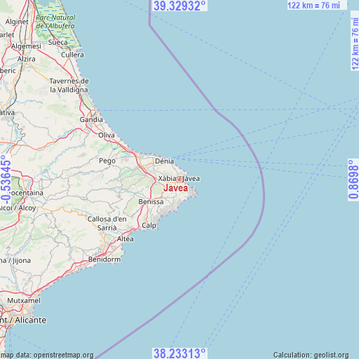
Javea GPS coordinates[2]
38° 46' 59.988" North, 0° 10' 0.012" East
| Map corner | latitude | longitude |
|---|---|---|
| Upper-left | 39.32932°, | -0.53645° |
| Center: | 38.78333°, | 0.16667° |
| Lower-right: | 38.23313°, | 0.8698° |
| Map W x H: | 121.9×121.9 km | = 75.7×75.7mi |
| max Lat: | 43.74134° ⇑83.4% North |
| Javea: | 38.78333° |
| min Lat: | ⇓16.6% South 27.64134° |
| min Long | Javea | max Long |
| -18.00367° | 0.16667° | 4.2899° |
| W 87.8%⇐ | ⇒12.2% E |
Elevation
Elevation of Javea is 14 m = 46 ft, and this is 584 m = 1916 ft below average elevation for this country.
| Max E: |
1682 m = 5518 ft | 97.3% |
| Avg. | 598 m = 1962 ft | |
| Javea | 14 m = 46 ft | |
Min E: |
0 m = 0 ft | 2.7% |
See also: Spain elevation on elevation.city.
Geographical zone
Javea is located in North temperate zone (between Tropic of Cancer and the Arctic Circle). Distance of this Northern Tropic circle is 1706.4 km =1060.3 mi to South.| Distance of | km | miles | from Javea |
|---|---|---|---|
| North Pole | 5694.8 | 3538.6 | to North |
| Arctic Circle | 3088.9 | 1919.4 | to North |
| Tropic Cancer | 1706.4 | 1060.3 | to South |
| Equator | 4312.3 | 2679.5 | to South |


Nearby cities:
15 places around Javea: (largest is in red/bold)
• Beniarbeig
15.3 km =9.5 mi,  286°
286°
• Benidoleig
17.1 km =10.6 mi,  273°
273°
• Benissa
12.8 km =8 mi,  233°
233°
• Benitachell
6 km =3.7 mi,  199°
199°
• Denia
8.3 km =5.2 mi,  320°
320°
• Gata de Gorgos
7.1 km =4.4 mi,  262°
262°
• Jalón
16.1 km =10 mi,  252°
252°
• Moraira
10.9 km =6.8 mi,  194°
194°
• Ondara
13.9 km =8.6 mi, 291°
• Pedreguer
11.5 km =7.1 mi,  275°
275°
• Sanet y Negrals
17.9 km =11.1 mi, 283°
• Senija
12.5 km =7.8 mi,  240°
240°
• Teulada
8.1 km =5 mi,  222°
222°
• Vergel
15.3 km =9.5 mi,  297°
297°
• els Poblets
14.9 km =9.3 mi, 301°
Sources, notices
• [Note1] Compared only with cities in Spain existing in our database
• [Src1] Map data: © OpenStreetMap contributors (CC-BY-SA)
• [Src2] Other city data from geonames.org with taken over terms of usage.
• [Src3] Geographical zone / Annual Mean Temperature by Robert A. Rohde @ Wikipedia
