Gamonal geodata
Gamonal (Castille-La Mancha) is a populated place; located in Spain in Europe/Madrid (GMT+2) time zone. With population of 976 people, there are 2986 cities with bigger population in this country. Compared to other cities in Spain, 70.9% of cities are located further ↑North; 71.9% of cities are located further →East and 67.5% of cities have higher elevation than Gamonal. Note1
Administrative division(s):
- Level 1: Castille-La Mancha
- Level 2: Province of Toledo
- Level 3: Talavera de la Reina


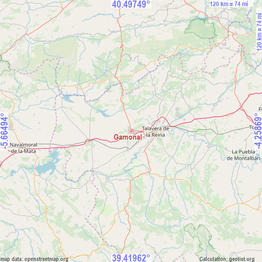
Gamonal GPS coordinates[2]
39° 57' 38.448" North, 4° 57' 42.516" West
| Map corner | latitude | longitude |
|---|---|---|
| Upper-left | 40.49749°, | -5.66494° |
| Center: | 39.96068°, | -4.96181° |
| Lower-right: | 39.41962°, | -4.25869° |
| Map W x H: | 119.8×119.8 km | = 74.4×74.4mi |
| max Lat: | 43.74134° ⇑70.9% North |
| Gamonal: | 39.96068° |
| min Lat: | ⇓29.1% South 27.64134° |
| min Long | Gamonal | max Long |
| -18.00367° | -4.96181° | 4.2899° |
| W 28.1%⇐ | ⇒71.9% E |
Elevation
Elevation of Gamonal is 426 m = 1398 ft, and this is 172 m = 564 ft below average elevation for this country.
| Max E: |
1682 m = 5518 ft | 67.5% |
| Avg. | 598 m = 1962 ft | |
| Gamonal | 426 m = 1398 ft | |
Min E: |
0 m = 0 ft | 32.5% |
See also: Spain elevation on elevation.city.
Geographical zone
Gamonal is located in North temperate zone (between Tropic of Cancer and the Arctic Circle). Distance of this Northern Tropic circle is 1837.3 km =1141.6 mi to South.| Distance of | km | miles | from Gamonal |
|---|---|---|---|
| North Pole | 5563.9 | 3457.2 | to North |
| Arctic Circle | 2958 | 1838 | to North |
| Tropic Cancer | 1837.3 | 1141.6 | to South |
| Equator | 4443.2 | 2760.9 | to South |


Nearby cities:
15 places around Gamonal: (largest is in red/bold)
• Alcañizo
13.8 km =8.6 mi,  242°
242°
• Calera y Chozas
8.8 km =5.5 mi,  191°
191°
• Cervera de los Montes
16.4 km =10.2 mi,  51°
51°
• Lagartera
21.3 km =13.2 mi,  253°
253°
• Las Herencias
10.7 km =6.6 mi,  161°
161°
• Mejorada
8.5 km =5.3 mi, 50°
• Montesclaros
16.3 km =10.1 mi,  6°
6°
• Navalcán
15.7 km =9.8 mi,  318°
318°
• Oropesa
18.7 km =11.6 mi,  255°
255°
• Parrillas
14.3 km =8.9 mi, 322°
• Segurilla
10.9 km =6.8 mi, 49°
• Sotillo de las Palomas
19.6 km =12.2 mi,  35°
35°
• Talavera de la Reina
11.2 km =7 mi,  88°
88°
• Torralba de Oropesa
16.7 km =10.4 mi, 259°
• Velada
2.2 km =1.4 mi,  325°
325°
Sources, notices
• [Note1] Compared only with cities in Spain existing in our database
• [Src1] Map data: © OpenStreetMap contributors (CC-BY-SA)
• [Src2] Other city data from geonames.org with taken over terms of usage.
• [Src3] Geographical zone / Annual Mean Temperature by Robert A. Rohde @ Wikipedia
